Toggle navigation
LMEC Home
Exhibitions
Georeferencing
Tools for Teachers
Collections
My Favorites
Sign Up / Log In
Search
Search the map portal
Map Collection
Map Collection
Map Sets
Search
Search
Search for
Search In
All Fields
Creator
Title
Subject
Place
Search All Digital Collections
Advanced Search
13385 Results
Filter your Search
Place
North and Central America
9,353
United States
7,078
Suffolk (county)
1,664
Boston
1,621
Europe
1,035
Canada
949
Massachusetts
794
New York
532
more
Place
»
Topic
Boston (Mass.)--Maps
741
City planning--Massachusetts--Boston--Maps
418
United States--History--Revolution, 1775-1783--Maps
329
United States--Maps
315
Urban renewal--Massachusetts--Boston--Maps
254
Real property--Massachusetts--Boston--Maps
252
Massachusetts--Maps
219
Insurance surveys
197
more
Topic
»
Date
Date range begin
–
Date range end
Current results range from
1482
to
2023
View distribution
Creator
United States. Hydrographic Office
595
Boston Redevelopment Authority
403
Des Barres, Joseph F. W. (Joseph Frederick Wallet), 1722-1824
247
Royal United Services Institute for Defence and Security Studies
160
Jefferys, Thomas, -1771
154
George, III, King of Great Britain, 1738-1820
152
George, IV, King of Great Britain, 1762-1830
151
O.H. Bailey & Co
148
more
Creator
»
Format
Maps/Atlases
13,205
Manuscripts
985
Prints
102
Books
49
Drawings/Illustrations
44
Photographs
15
Objects/Artifacts
13
Documents
7
more
Format
»
Georeferenced
Yes
979
No
12,406
Collection
Norman B. Leventhal Map Center Collection
8,891
American Revolutionary War-Era Maps
3,305
Boston and New England Maps
2,804
Urban Maps
2,397
Maritime Charts and Atlases
1,150
William L. Clements Library Collection
910
Library of Congress Collection
618
Boston Redevelopment Authority Collection
475
more
Collection
»
Available to use
No known restrictions
9,952
Creative Commons license
1,677
Search Constraints
Sort by date (asc)
relevance
title
date (asc)
date (desc)
Number of results to display per page
50 per page
10
per page
20
per page
50
per page
100
per page
View results as:
grid view
map view
Search Results
12351.
The good neighbor pictorial map of South America
12352.
Japanese fishing, areas and seasons
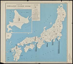
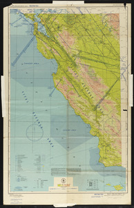
12353.
Land utilization in Korea
12354.
Morocco, location of mineral resources
12355.
Philippine Islands population, 1939 census
12356.
Philippine Islands radio stations and cables
12357.
Radiotelegraph and radiotelephone communication systems of France : radiotelegraph communication system of the French Ministry...
12358.
Saishin ōshū daichizu
12359.
Solomon Islands long range air navigation chart
12360.
South Pacific Ocean, Solomon Islands, Guadalcanal and Florida Is. with a portion of Malaita I. : from British surveys to 1912
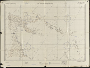
12361.
South-east New Guinea
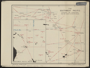
12362.
The southwest Pacific
12363.
Total war battle map
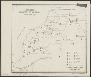
12364.
Tribal map of Morocco
12365.
The victory war map
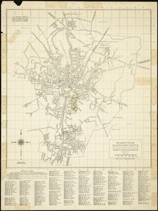
12366.
Wakefield, Massachusetts
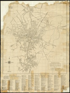
12367.
Wakefield, Massachusetts
12368.
AAF special chart - Gulf of Oman
12369.
Algeria and Tunisia, port capacities and major transport routes
12370.
Boston Elevated Railway system route map
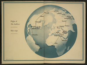
12371.
Flight of "The Gulliver"
12372.
Global map for global war and global peace
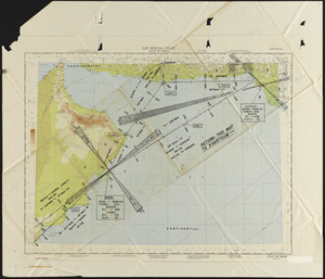
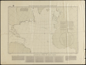
12373.
Great circle airways
12374.
Invasion and total war victory maps : with decorations, illustrations and military and naval insignia
12375.
Iraq water supply and land use
12376.
Japan, the target : a pictorial Jap-map
12377.
Mr. Charles M. Holmes, New Bedford, Mass. [insurance map]
12378.
Newsmap : week of October 14 to October 21, 215th week of the war, 97th week of U.S. participation. Monday, October 25, 1943
12379.
Newsmap : week of December 16 to December 22, 224th week of the war, 106th week of U.S. Participation. Monday, December 27, 1943
12380.
A pictorial map of loveland
12381.
Railroads of Lithuania, 1939
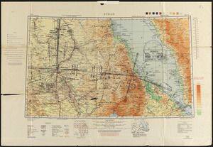
12382.
Roads and communications of Sinkiang
12383.
San Francisco (RS-1) sectional aeronautical chart
12384.
Sudan
12385.
Town of Brookline Mass. Assessors' plans 1943
12386.
The adventures of Mark Twain
12387.
Atlas of town of Weymouth Massachusetts
12388.
Caroline Islands, Yap Island
12389.
China east coast population density
12390.
Continental Screw Company, New Bedford, Mass. [insurance map]
12391.
Draper Corporation, Guilford, Maine [insurance map]
12392.
Eight views of the world
12393.
Germany, concentration camps (June--1944)
12394.
Germany, postal administrative districts, March 1943
12395.
Great Britain, her natural & industrial resources
12396.
Great circle sailing chart of the North Atlantic Ocean
12397.
Indians of the U.S.A.
12398.
Italy with Vatican City
12399.
Japan, population changes 1935-1940
12400.
Mercator map of the world united : a pictorial history of transport and communications and paths to permanent peace
‹ Prev
Next ›
1
2
…
244
245
246
247
248
249
250
251
252
…
267
268