Toggle navigation
LMEC Home
Exhibitions
Georeferencing
Tools for Teachers
Collections
My Favorites
Sign Up / Log In
Search
Search the map portal
Map Collection
Map Collection
Map Sets
Search
Search
Search for
Search In
All Fields
Creator
Title
Subject
Place
Search All Digital Collections
Advanced Search
13385 Results
Filter your Search
Place
North and Central America
9,353
United States
7,078
Suffolk (county)
1,664
Boston
1,621
Europe
1,035
Canada
949
Massachusetts
794
New York
532
more
Place
»
Topic
Boston (Mass.)--Maps
741
City planning--Massachusetts--Boston--Maps
418
United States--History--Revolution, 1775-1783--Maps
329
United States--Maps
315
Urban renewal--Massachusetts--Boston--Maps
254
Real property--Massachusetts--Boston--Maps
252
Massachusetts--Maps
219
Insurance surveys
197
more
Topic
»
Date
Date range begin
–
Date range end
Current results range from
1482
to
2023
View distribution
Creator
United States. Hydrographic Office
595
Boston Redevelopment Authority
403
Des Barres, Joseph F. W. (Joseph Frederick Wallet), 1722-1824
247
Royal United Services Institute for Defence and Security Studies
160
Jefferys, Thomas, -1771
154
George, III, King of Great Britain, 1738-1820
152
George, IV, King of Great Britain, 1762-1830
151
O.H. Bailey & Co
148
more
Creator
»
Format
Maps/Atlases
13,205
Manuscripts
985
Prints
102
Books
49
Drawings/Illustrations
44
Photographs
15
Objects/Artifacts
13
Documents
7
more
Format
»
Georeferenced
Yes
979
No
12,406
Collection
Norman B. Leventhal Map Center Collection
8,891
American Revolutionary War-Era Maps
3,305
Boston and New England Maps
2,804
Urban Maps
2,397
Maritime Charts and Atlases
1,150
William L. Clements Library Collection
910
Library of Congress Collection
618
Boston Redevelopment Authority Collection
475
more
Collection
»
Available to use
No known restrictions
9,952
Creative Commons license
1,677
Search Constraints
Sort by date (asc)
relevance
title
date (asc)
date (desc)
Number of results to display per page
50 per page
10
per page
20
per page
50
per page
100
per page
View results as:
grid view
map view
Search Results
11801.
Ethnographical map of Hungary based on the density of population
11802.
Fairhaven Mills (Cotton Mill), New Bedford, Mass.
11803.
Fault map of the state of California
11804.
Glendale Elastic Fabrics Co., Easthampton, Mass. [insurance map]
11805.
The great north woods tourist and fishing district of Wisconsin : ideal location for summer homes
11806.
Hoosac Cotton Mills "Nos. 1 & 2 Mills," North Adams, Mass. [insurance map]
11807.
The Long Trail of the Green Mountain Club of Vermont : Trout Club to Bolton
11808.
Manomet Mills "Mill No. 4" (Cotton Mill), New Bedford, Mass.
11809.
Map of Africa : and adjoining portions of Europe and Asia
11810.
Map of Bath, Maine
11811.
Map of Lynnfield, in Essex County, Massachusetts
11812.
Map of the city of Boston
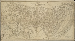
11813.
Map of the city of Cambridge
11814.
Oil and gas fields of the state of Kentucky
11815.
La Paz : South America 1:1,000,000
11816.
The Price & Lee Co's map of Orange
11817.
Radio map of the United States
11818.
Rand McNally & Co's new commercial map of Europe
11819.
Richards standard atlas of the city of Worcester, Massachusetts
11820.
State of Kentucky, stations and transmission lines used in public service in 1921
11821.
State of West Virginia, stations and transmission lines used in public service in 1921
11822.
Stations and transmission lines used in public service in 1919 : [Massachusetts, Rhode Island, and Connecticut]
11823.
Textile Warehouse Co. Inc., Beacon Mfg. Company, Tenant, New Bedford, Mass. [insurance map]
11824.
Traffic map of down-town Boston : parking spaces and one-way streets
11825.
Via RCA : a direct marine radio service to and from ships at sea
11826.
West Indies, Virgin Islands, St. Thomas
11827.
Western Front (British & German attacks)
11828.
Železnička i brodarska karta Kraljevine Srba Hrvata i Slovenaca = Carte des chemins de fer et de naviation du Royaume des...
11829.
Androscoggin Mills (Cotton Mill), Lewiston, Me. [insurance map]
11830.
Atlas of the city of Quincy, Norfolk County, Massachusetts : compiled from the latest plans and original surveys
11831.
Boston Harbor
11832.
Diagram showing the Changuinola Railroad lines
11833.
Drake's silver map : British Museum
11834.
Frank W. Smith Co. (Silver Ware), Gardner, Mass. [insurance map]
11835.
Greater Macon
11836.
Landing facilities and proposed airway system in the United States, 1923
11837.
A map of some of the south and east bounds of Pennsylvania in America, being partly inhabited
11838.
Map showing transmission lines of the Shawinigan Water & Power Co.
11839.
Nashawena Mills (Cotton Mill), New Bedford, Mass. [insurance map]
11840.
New Bedford Storage Warehouse Co. "Union Stores," New Bedford, Mass. [insurance map]
11841.
Oil and gas fields of the state of California
11842.
Physiographic diagram of Europe
11843.
Plan of railway stations and sidings in South Africa
11844.
The Price & Lee Co's map of the city of New Haven, Connecticut
11845.
Southern Railway system
11846.
State of Maine
11847.
United States of America
11848.
Ward 1 [of Boston]
11849.
Winslow & McKenzie "Warehouse," New Bedford, Mass. [insurance map]
11850.
Ziron 1920 political map
‹ Prev
Next ›
1
2
…
233
234
235
236
237
238
239
240
241
…
267
268