Toggle navigation
LMEC Home
Exhibitions
Georeferencing
Tools for Teachers
Collections
My Favorites
Sign Up / Log In
Search
Search the map portal
Map Collection
Map Collection
Map Sets
Search
Search
Search for
Search In
All Fields
Creator
Title
Subject
Place
Search All Digital Collections
Advanced Search
84 Results
My Search
Start Over
"G1105 .J4 1768"
Remove constraint "G1105 .J4 1768"
Filter your Search
Place
North and Central America
56
United States
21
Canada
10
North America
6
Atlantic Ocean
4
French Guiana
4
Québec
4
West Indies
4
more
Place
»
Topic
North America--Maps--Early works to 1800
6
America--Discovery and Exploration--Maps--Early works to 1800
5
Tactics--Maps--Early works to 1800
5
Braddock's Campaign, 1755--Maps
4
Québec (Québec)--Maps--Early works to 1800
4
United States--History--French and Indian War, 1754-1763--Maps
4
United States--History--French and Indian War, 1754-1763--Maps--Early works to 1800
4
Basse-Terre (Guadeloupe)--Maps--Early works to 1800
3
more
Topic
»
Date
Date range begin
–
Date range end
Current results range from
1755
to
1768
View distribution
Creator
Jefferys, Thomas, -1771
76
Sayer, Robert, 1725-1794
66
Celi, Francisco Mathias
8
Green, John, -1757
6
Orme, Robert, -1781
6
Bully, le sieur
2
Caylus, de, engineer
2
Hutchins, Thomas, 1730-1789
2
more
Creator
»
Format
Maps/Atlases
84
Georeferenced
Yes
1
No
83
Collection
Norman B. Leventhal Map Center Collection
84
American Revolutionary War-Era Maps
57
Maritime Charts and Atlases
19
Boston and New England Maps
2
Urban Maps
1
Available to use
No known restrictions
84
Search Constraints
Sort by relevance
relevance
title
date (asc)
date (desc)
Number of results to display per page
20 per page
10
per page
20
per page
50
per page
100
per page
View results as:
grid view
map view
Search Results
21.
The Dutch colony of Surinam, as laid down by L: Colonel Spiering, Chief Engineer at Surinam
22.
Florida from the latest authorities
23.
A general map of the middle British colonies in America : viz. Virginia, Maryland, Delaware, Pensilvania, New-Jersey, New-York,...
24.
The grand bay of Nipe on the north side of Cuba from Spanish draughts ; Plan of Puerto de Baracoa
25.
Guadaloupe, one of the Caribbee Islands subject to France in the West Indies
26.
The island and colony of Cayenne subject to the French, on the continent of South America
27.
The island of Hispaniola called by the French St. Domingo : subject to France & Spain
28.
Jamaica
29.
A large and particular plan of Shegnekto Bay, and the circumjacent country, with the forts and settlements of the French 'till...
30.
A map of Canada and the north part of Louisiana with the adjacent countrys
31.
A map of South Carolina and a part of Georgia : containing the whole sea-coast; all the islands, inlets, rivers, creeks,...
32.
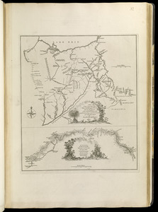
A map of the country between Will's Creek & Monongahela River shewing the rout and encampments of the English army in 1755
33.
A map of the country on the Ohio and Muskingum Rivers : shewing the situation of the Indian towns with respect to the army...
34.
A map of the island of Guadaloupe
35.
A map of the isle of Cuba : with the Bahama Islands, Gulf of Florida, and Windward Passage ; drawn from English and Spanish...
36.
A map of the most inhabited part of New England : containing the provinces of Massachusets Bay and New Hampshire, with the...
37.
A map of the most inhabited part of Virginia containing the whole province of Maryland with part of Pensilvania, New Jersey and...
38.
A map of the n.e. part of Asia, and n.w. parts of America, shewing their situations with respect to Japan
39.
A map of the several dispositions of the English Fleet & Army on the River St. Laurence to the taking of Quebec
40.
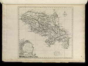
Martinico, one of the Caribbee Islands in the West Indies : subject to the French
‹ Prev
Next ›
1
2
3
4
5