Toggle navigation
LMEC Home
Exhibitions
Georeferencing
Tools for Teachers
Collections
My Favorites
Sign Up / Log In
Search
Search the map portal
Map Collection
Map Collection
Map Sets
Search
Search
Search for
Search In
All Fields
Creator
Title
Subject
Place
Search All Digital Collections
Advanced Search
978 Results
My Search
Start Over
More Like
commonwealth-oai:n2971z39v
Remove constraint More Like: commonwealth-oai:n2971z39v
Filter your Search
Place
North and Central America
950
United States
690
Canada
205
New York
192
Quebec
111
Massachusetts
91
Suffolk (county)
73
Boston
66
more
Place
»
Topic
United States--History--Revolution, 1775-1783--Maps
330
United States--History--French and Indian War, 1754-1763--Maps
149
Saint Lawrence River--Maps
43
Boston (Mass.)--Aerial views
41
Newport (R.I.)--Maps
27
New York (State)--Maps
24
Hudson River (N.Y. and N.J.)--Maps
21
Québec (Québec)--Maps
21
more
Topic
»
Date
Date range begin
–
Date range end
Current results range from
1700
to
1980
View distribution
Creator
Rocque, Mary Ann
29
Holland, Samuel, 1728-1801
25
Jefferys, Thomas, -1771
25
Montrésor, John, 1736-1799
25
Bellin, Jacques Nicolas, 1703-1772
24
Clinton, Henry, Sir, 1738?-1795
19
Robert Sayer and John Bennett (Firm)
16
Hills, John, active 1777-1819
13
more
Creator
»
Format
Maps/Atlases
962
Drawings/Illustrations
11
Documents
5
Manuscripts
5
Prints
2
Georeferenced
Yes
4
No
974
Collection
American Revolutionary War-Era Maps
929
William L. Clements Library Collection
909
Norman B. Leventhal Map & Education Center Collection
49
Boston and New England Maps
44
Urban Maps
40
Maps from AAS
7
Boston Redevelopment Authority Collection
3
Newberry Library Collection
3
more
Collection
»
Available to use
No known restrictions
52
Creative Commons license
5
Search Constraints
Sort by relevance
relevance
title
date (asc)
date (desc)
Number of results to display per page
20 per page
10
per page
20
per page
50
per page
100
per page
View results as:
grid view
map view
Search Results
381.
An accurate map of the West Indies, containing the Bahama & Caribbe islands the Great & Little Antilles; with the Leward and...
382.
Action between Genl. St Clairs army & that of the American Indians Novr. 4th 1791 : collected from his public letter
383.
Admiral George Clinton's lands in the "Oblong"
384.
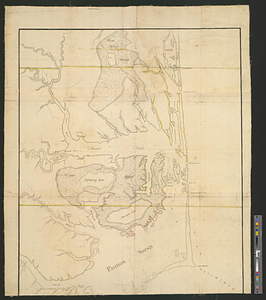
Albemarle and Pamlico Sounds
385.
Allegheny River and French Creek
386.
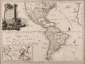
America, engraved according to recent geographical observations
387.
L'Amérique, divisée par grands etats
388.
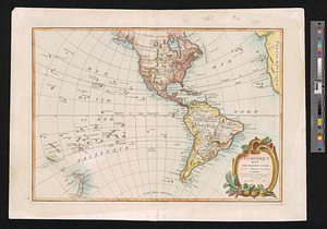
L'Amérique Septentrionale
389.
Amérique Septentrionale divisée en ses principaux etats
390.
Attaques des forts de Chouaguen en Amérique pris par les français commandés par le Marquis de Montcalm le 14 Août 1756
391.
Attaques des retranchemens devant le fort Carillon en Amérique par les anglais commandés par le général Abercrombie contre les...
392.
Attaques du fort William-Henri en Amérique par les troupes français aux ordres du Marquis de Montcalm prise de ce fort le 7...
393.
Baye et port d'Yorc capitale de la Nouvelle Yorc
394.
Block between Sixteenth and Seventeenth Streets and Chestnut and Market Streets, Philadelphia, 1771
395.
British attack upon Ticonderoga, July 7 & 8, 1758
396.
The British colonies in North America
397.
British dominions in America, drawn from the latest and best authorities
398.
Campaign of Major General Anthony Wayne, 1793-94
399.
Canada
400.
Cantonment of the forces in N. America 1766
‹ Prev
Next ›
1
2
…
16
17
18
19
20
21
22
23
24
…
48
49