Toggle navigation
LMEC Home
Exhibitions
Georeferencing
Tools for Teachers
Collections
My Favorites
Sign Up / Log In
Search
Search the map portal
Map Collection
Map Collection
Map Sets
Search
Search
Search for
Search In
All Fields
Creator
Title
Subject
Place
Search All Digital Collections
Advanced Search
60 Results
My Search
Start Over
More Like
commonwealth:z603vq36t
Remove constraint More Like: commonwealth:z603vq36t
Filter your Search
Place
North and Central America
60
New York
39
New Jersey
29
United States
19
New England
8
Pennsylvania
7
Northeastern United States
6
Middle Atlantic
4
more
Place
»
Topic
New Jersey--Maps--Early works to 1800
30
New York (State)--Maps--Early works to 1800
26
New Jersey--Administrative and political divisions--Maps--Early works to 1800
9
Pennsylvania--Maps--Early works to 1800
9
New England--Maps--Early works to 1800
8
Northeastern States--Maps--Early works to 1800
7
New York (State)--Administrative and political divisions--Maps--Early works to 1800
6
Middle Atlantic States--Maps--Early works to 1800
5
more
Topic
»
Date
Date range begin
–
Date range end
Current results range from
1636
to
1845
View distribution
Creator
Faden, William, 1749-1836
10
Sauthier, Claude Joseph
5
Bancker, Gerard, 1740-1799
4
Kitchin, Thomas, 1718-1784
4
Ratzer, Bernard
4
Homann Erben (Firm)
3
Amherst, Jeffery Amherst, Baron, 1717-1797
2
Andrews, Peter, active 1765-1782
2
more
Creator
»
Format
Maps/Atlases
60
Manuscripts
2
Georeferenced
Yes
6
No
54
Collection
American Revolutionary War-Era Maps
45
New York Public Library Collection
27
Norman B. Leventhal Map Center Collection
20
Richard H. Brown Revolutionary War Map Collection at Mount Vernon
8
Sidney R. Knafel Map Collection at Phillips Academy
4
Maritime Charts and Atlases
3
Urban Maps
3
Mapping Boston Collection
2
more
Collection
»
Available to use
Creative Commons license
38
No known restrictions
18
Search Constraints
Sort by date (asc)
relevance
title
date (asc)
date (desc)
Number of results to display per page
20 per page
10
per page
20
per page
50
per page
100
per page
View results as:
grid view
map view
Search Results
1.
Noua Anglia, Nouum Belgium, et Virginia
2.
Pas caert van Nieu Nederland, Virginia en Nieu Engelant
3.
Paskaerte van de Zuÿdt en Noordt Revier in Nieu Nederlant streckende van Cabo Hinloopen tot Rechkewach
4.
A map of New England and New York
5.
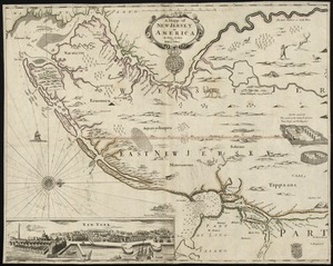
A mapp of New Jersey in America
6.
New England and New York
7.
Nouvelle Angleterre et Nouvel York
8.
A new map of Virginia, Mary-land and the improved parts of Penn-sylvania & New Jersey
9.
New York and Perthamboy Harbours
10.
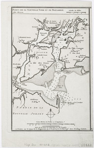
Ports de la Nouvelle York et Pertamboy : aux anglois
11.
Map no. I
12.
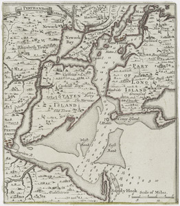
A map of the eastern part of the province of New York with part of New Jersey, & c
13.
Pensylvania Nova Jersey et Nova York cum Regionibus ad Fluvium Delaware in America sitis
14.
Karte von Neu England, Neu Yorck und Pensilvanien : sur Allgemeinen historie der reisen
15.
Lauff des flusses St. Laurentzi von Quebec bis an den See Ontario : 2. bladt
16.
New Engelland, New York, New Yersey und Pensilvania
17.
Porti della Nuova York e Perthamboy
18.
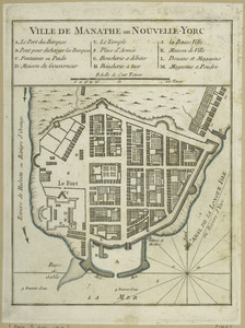
Ville de Manathe ou Nouvelle-Yorc
19.
The provinces of New York, and New Jersey; with part of Pensilvania, and the governments of Trois Rivières, and Montreal
20.
Part of east New Jarsey, New York, and Connecticut
‹ Prev
Next ›
1
2
3