Toggle navigation
LMEC Home
Exhibitions
Georeferencing
Tools for Teachers
Collections
My Favorites
Sign Up / Log In
Search
Search the map portal
Map Collection
Map Collection
Map Sets
Search
Search
Search for
Search In
All Fields
Creator
Title
Subject
Place
Search All Digital Collections
Advanced Search
198 Results
My Search
Start Over
More Like
commonwealth:z603vp41g
Remove constraint More Like: commonwealth:z603vp41g
Filter your Search
Place
North America
171
North and Central America
50
United States
28
Canada
17
South America
9
New England
6
New York
6
West Indies
6
more
Place
»
Topic
North America--Maps--Early works to 1800
180
Great Britain--Colonies--America--Maps--Early works to 1800
19
United States--Maps--Early works to 1800
14
Canada--Maps--Early works to 1800
12
British--America--Maps--Early works to 1800
10
South America--Maps--Early works to 1800
8
France--Colonies--America--Maps--Early works to 1800
7
West Indies--Maps--Early works to 1800
6
more
Topic
»
Date
Date range begin
–
Date range end
Current results range from
1528
to
1850
View distribution
Creator
Mitchell, John, 1711-1768
13
Jefferys, Thomas, -1771
12
Sayer, Robert, 1725-1794
12
Moll, Herman, d. 1732
11
Anville, Jean Baptiste Bourguignon d', 1697-1782
9
Kitchin, Thomas, 1718-1784
6
Hinton, John, -1781
5
Kitchin, Thomas, d. 1784
5
more
Creator
»
Format
Maps/Atlases
198
Manuscripts
2
Georeferenced
Yes
5
No
193
Collection
American Revolutionary War-Era Maps
133
Norman B. Leventhal Map Center Collection
115
New York Public Library Collection
46
Richard H. Brown Revolutionary War Map Collection at Mount Vernon
18
Mapping Boston Collection
9
Sidney R. Knafel Map Collection at Phillips Academy
8
British Library Collection
3
New-York Historical Society Collection
3
more
Collection
»
Available to use
No known restrictions
109
Creative Commons license
78
Search Constraints
Sort by date (desc)
relevance
title
date (asc)
date (desc)
Number of results to display per page
20 per page
10
per page
20
per page
50
per page
100
per page
View results as:
grid view
map view
Search Results
1.
Copy of a map presented to the Congres [sic]
2.
North America
3.
British colonies in North America : drawn from the best authorities
4.
North America, drawn from the best authorities
5.
The state of New York, compiled from the most authentic information, 1796
6.
Map of the northern, or, New England states of America, comprehending Vermont, New Hampshire, District of Main, Massachusetts,...
7.
Map of the northern, or, New England states of America, comprehending Vermont, New Hampshire, District of Main, Massachusetts,...
8.
A New and correct map of the British colonies in North America comprehending eastern Canada with the province of Quebec, New...
9.
A New map of North America with the West India Islands : divided according to the preliminary articles of peace, signed at...
10.
A new map of the United States of North America with the British dominions on that continent &c
11.
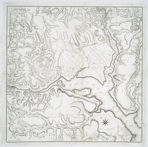
Territory of Columbia
12.
Carte d'un partie de l'Amerique Septentrionale : ou est tracée notre route d'Halifax à New York, par Quebec, Montreal, le Lac...
13.
Amerique septentrionale divisée en ses principales parties
14.
LʼAmérique Septentrionale et Méridionale divisée suivant ses différens pays
15.
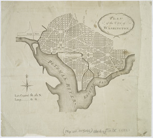
Plan of the city of Washington
16.
A map of the northern and middle states : comprehending the western territory & the British dominions in North America : from...
17.
North America
18.
Carte d'Amerique : divisée en ses principaux etats avec les nouvelles decouvertes faites au Nord et dans la Mer du Sud par les...
19.
Generalkarte von Nord America samt den Westindischen inseln
20.
New & accurate map of North America : with the new discovered islands on the north east coast of Asia
‹ Prev
Next ›
1
2
3
4
5
…
9
10
![Copy of a map presented to the Congres [sic]](https://bpldcassets.blob.core.windows.net/derivatives/images/commonwealth:z603vn16x/image_thumbnail_300.jpg)