Toggle navigation
LMEC Home
Exhibitions
Georeferencing
Tools for Teachers
Collections
My Favorites
Sign Up / Log In
Search
Search the map portal
Map Collection
Map Collection
Map Sets
Search
Search
Search for
Search In
All Fields
Creator
Title
Subject
Place
Search All Digital Collections
Advanced Search
300 Results
My Search
Start Over
More Like
commonwealth:z603vj614
Remove constraint More Like: commonwealth:z603vj614
Filter your Search
Place
North and Central America
237
United States
146
Canada
75
Suffolk (county)
61
Boston
60
Nova Scotia
24
Boston Harbor
16
Minas Basin
9
more
Place
»
Topic
Manuscript maps--Early works to 1800
138
Coasts--Nova Scotia--Maps
62
Fortification--Massachusetts--Boston--Maps--Early works to 1800
30
Boston (Mass.)--History--Revolution, 1775-1783--Maps--Early works to 1800
26
Boston (Mass.)--Buildings, structures, etc--Maps, Manuscript--Early works to 1800
17
Boston (Mass.)--History--Siege, 1775-1776--Maps--Early works to 1800
11
Fortification--Massachusetts--Boston--Maps, Manuscript--Early works to 1800
11
Coasts--Nova Scotia--Pictorial works
10
more
Topic
»
Date
Date range begin
–
Date range end
Current results range from
1700
to
1899
View distribution
Creator
Des Barres, Joseph F. W. (Joseph Frederick Wallet), 1722-1824
95
Dumont de Montigny
14
Adlum, John, 1759-1836
9
Bingham, William, 1752-1804
9
Page, Thomas Hyde, Sir, 1746-1821
9
Aitken, Robert, 1735-1802
7
Montrésor, John, 1736-1799
7
Beaurain, Jean de, 1696-1771
5
more
Creator
»
Format
Maps/Atlases
297
Manuscripts
172
Drawings/Illustrations
2
Prints
1
Georeferenced
Yes
9
No
291
Collection
American Revolutionary War-Era Maps
294
Library of Congress Collection
228
Newberry Library Collection
39
Boston and New England Maps
20
Norman B. Leventhal Map Center Collection
20
Maritime Charts and Atlases
18
Urban Maps
14
Mapping Boston Collection
10
more
Collection
»
Available to use
Creative Commons license
250
No known restrictions
11
Search Constraints
Sort by title
relevance
title
date (asc)
date (desc)
Number of results to display per page
20 per page
10
per page
20
per page
50
per page
100
per page
View results as:
grid view
map view
Search Results
21.
Buzzards Bay and shoals of Nantucket
22.
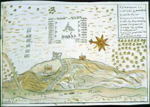
Campement de l'armée à Tombecbe
23.
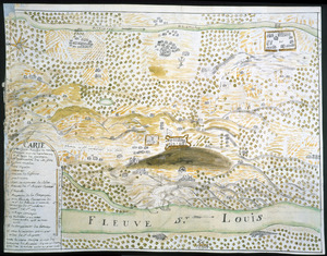
[Campement] de l'armée franc̦oise [devant u]n village des ennemis, les Chicachas le 26 [de mais] 1736
24.
Canso Harbor
25.
Canso Harbor
26.
Cantonment of His Majesty's forces in N. America : according to the disposition now made & to be compleated as soon as...
27.
Cantonment of the forces in North America 11th. Octr. 1765
28.
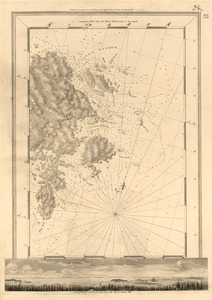
Cape Blowmedown ; Cape Split ; Spencers Island and the entrance of Mines Bason ; Isle Haut and Cape Chegnecto
29.
Cape Blowmedown ; Cape Split ; The entrance of Mines Bason ; Isle Haut and Cape Chegnecto
30.
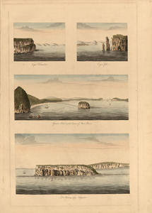
Cape Prospect ... Cape Sambro ... ; The high lands of Haspotagoen ... ; The Ovens at the entrance of Lunenburg Bay ; Cape Sable...
31.
Cape Prospect ... Cape Sambro ... ; The high lands of Haspotagoen ... ; The Ovens at the entrance of Lunenburg Bay ; Cape Sable...
32.
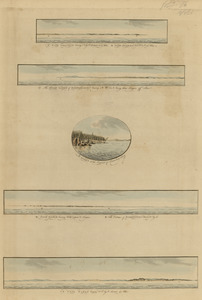
Cape St. Mary n.e. one mile ; South entrance of Grand Passage ; St. Marys Bay
33.
Carta esférica de la canal entre Puerto Rico y Santo Domingo
34.
Carta esférica de la Ysla de la Granada
35.
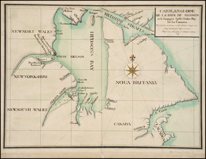
Carte angloise de la Baye de Hudson ou la compagnie apellee Hudson Bay fait son commerce : tirée de la liasse des concecions...
36.
Carte de la coste de la Louisiane, depuis la Baye de St. Bernard jusqu'a celle de Saint Joseph : ou tous les ports, rades, et...
37.
Carte de la rivire du Cannada, la Terre Nevf, Cape Britton et la cotte de Lacadie
38.
Carte de l'entrée du port et rade de Pensacola
39.
Carte du Cap Franc̨ois de Saint Domingue, de l'isle de Cuba, de la Jamaique avec le canal de Bahama, l'entrée du fleuve St....
40.
Carte du Fort Rozalie des Natches franc̦ois avec ses dependances et village des sauvages
‹ Prev
Next ›
1
2
3
4
5
6
…
14
15

![[Campement] de l'armée franc̦oise [devant u]n village des ennemis, les Chicachas le 26 [de mais] 1736](https://bpldcassets.blob.core.windows.net/derivatives/images/commonwealth:z603vn65v/image_thumbnail_300.jpg)