Toggle navigation
LMEC Home
Exhibitions
Georeferencing
Tools for Teachers
Collections
My Favorites
Sign Up / Log In
Search
Search the map portal
Map Collection
Map Collection
Map Sets
Search
Search
Search for
Search In
All Fields
Creator
Title
Subject
Place
Search All Digital Collections
Advanced Search
43 Results
My Search
Start Over
More Like
commonwealth:z603vh936
Remove constraint More Like: commonwealth:z603vh936
Filter your Search
Place
North and Central America
33
United States
29
Charleston (county)
17
Charleston
16
Georgia
7
South Carolina
6
Boston
4
New York
4
more
Place
»
Topic
Charleston (S.C.)--Maps--Early works to 1800
12
South Carolina--Maps--Early works to 1800
6
Georgia--Maps--Early works to 1800
5
United States--History--Revolution, 1775-1783--Maps--Early works to 1800
4
Yorktown (Va.)--History--Siege, 1781--Maps--Early works to 1800
4
American literature--Revolutionary period, 1775-1783
3
Coasts--Georgia--Maps--Early works to 1800
3
Coasts--South Carolina--Maps--Early works to 1800
3
more
Topic
»
Date
Date range begin
–
Date range end
Current results range from
1737
to
1816
View distribution
Creator
Faden, William, 1749-1836
9
Aitken, Robert, 1735-1802
6
Conder, Thomas, 1746 or 1747-1831
3
Des Barres, Joseph F. W. (Joseph Frederick Wallet), 1722-1824
3
Buckland, James, 1710 or 1711-1790
2
Bull, William, 1710-1791
2
De Brahm, John Gerar William, 1717-approximately 1799
2
Dilly, Charles, 1739-1807
2
more
Creator
»
Format
Maps/Atlases
35
Books
7
Manuscripts
2
Prints
1
Georeferenced
No
43
Collection
American Revolutionary War-Era Maps
38
Harvard Map Collection
31
Norman B. Leventhal Map Center Collection
9
Maritime Charts and Atlases
7
British Library Collection
2
Boston and New England Maps
1
Library of Congress Collection
1
Urban Maps
1
Available to use
Creative Commons license
34
No known restrictions
9
Search Constraints
Sort by title
relevance
title
date (asc)
date (desc)
Number of results to display per page
20 per page
10
per page
20
per page
50
per page
100
per page
View results as:
grid view
map view
Search Results
1.
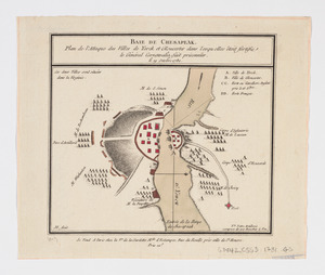
Baie de Chesapeak : plan de l'attaque des villes de Yorck et Gloucester dans lesquelles êtoit fortifie le Général Cornwalia,...
2.
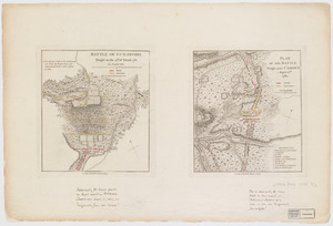
Battle of Guildford, fought on the 15th of March 1781. Plan of the batttle fought near Camden, August 16th, 1780
3.
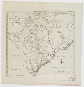
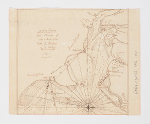
The Carolina's with part of Georgia
4.
Caroline méridionale et partie de la Georgie
5.
Carte générale des colonies Angloises : dans l'Amérique Septentrionale
6.
Charles Town, South Carolina : with a chart of the bars & harbour
7.
Charles-town, capitale de la Caroline
8.
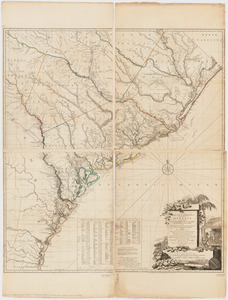
A chart of South Carolina and Georgia
9.
A chart of South Carolina and Georgia
10.
A chart of South Carolina and Georgia
11.
Charts of the coast and harbors of New England : [title page]
12.
Curious enigmatical epitaphs
13.
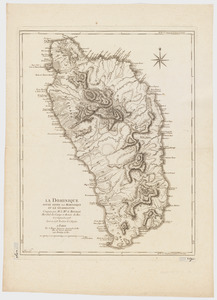
La Dominique située entre La Martinique et La Guadeloupe : conquise par M. le Mis. de Bouillé Marechal des camps et armées du...
14.
Exact plan of General Gage's lines on Boston Neck in America
15.
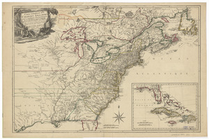
A general map of the southern British colonies in America comprehending North and South Carolina, Georgia, East and West...
16.
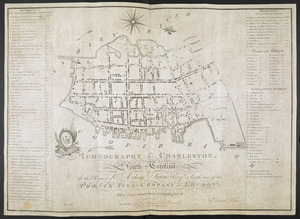
ICHNOGRAPHY OF CHARLESTON, South Carolina
17.
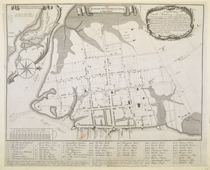
The ICHNOGRAPHY of CHARLES-TOWN, at High Water
18.
A map of South Carolina and a part of Georgia : Containing the whole sea-coast; all the islands, inlets, rivers, creeks,...
19.
A map of the country in which the army under Lt. General Burgoyne acted in the campaign of 1777 : shewing the marches of the...
20.
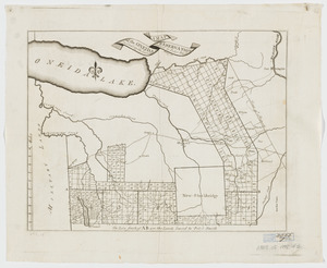
A map of the Oneida Reservation : including the lands leased to Peter Smith
‹ Prev
Next ›
1
2
3