Toggle navigation
LMEC Home
Exhibitions
Georeferencing
Tools for Teachers
Collections
My Favorites
Sign Up / Log In
Search
Search the map portal
Map Collection
Map Collection
Map Sets
Search
Search
Search for
Search In
All Fields
Creator
Title
Subject
Place
Search All Digital Collections
Advanced Search
175 Results
My Search
Start Over
More Like
commonwealth:z603vh28w
Remove constraint More Like: commonwealth:z603vh28w
Filter your Search
Place
North and Central America
112
West Indies
51
United States
50
Canada
22
North America
20
Caribbean Sea
13
New York
11
Boston
10
more
Place
»
Topic
West Indies--Maps
52
United States--Maps
27
North America--Maps
20
Canada--Maps
14
Caribbean Area--Maps
13
Central America--Maps
11
Boston (Mass.)--Maps
9
New England--Maps
9
more
Topic
»
Date
Date range begin
–
Date range end
Current results range from
1740
to
1993
View distribution
Creator
Reid, John, 1764?-1828
11
Bellin, Jacques Nicolas, 1703-1772
9
Farwell, John Whittemore, 1843-1929
9
Kitchin, Thomas, 1718-1784
9
Carleton, Osgood, 1742-1816
6
Tanner, Benjamin, 1775-1848
6
Anderson, Alexander, 1775-1870
5
Gibson, J. (John), active 1750-1792
5
more
Creator
»
Format
Maps/Atlases
175
Manuscripts
12
Georeferenced
Yes
20
No
155
Collection
American Revolutionary War-Era Maps
145
American Antiquarian Society Collection
138
Norman B. Leventhal Map Center Collection
30
William L. Clements Library Collection
7
Maritime Charts and Atlases
4
Boston and New England Maps
1
Available to use
No known restrictions
30
Creative Commons license
1
Search Constraints
Sort by date (desc)
relevance
title
date (asc)
date (desc)
Number of results to display per page
20 per page
10
per page
20
per page
50
per page
100
per page
View results as:
grid view
map view
Search Results
1.
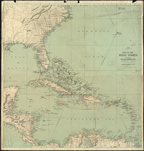
North Atlantic Ocean, West Indies
2.
A map of the West Indies and the Spanish Main
3.
The countries of the Caribbean : including Mexico, Central America, the West Indies and the Panama Canal
4.
Map of Central America, Cuba, Porto Rico, and the islands of the Caribbean Sea
5.
The Evening Post map of the West Indies
6.
Map of the seat of war : showing the only practical method by which the movements of the warships of both nations can be...
7.
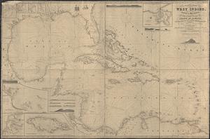
Map of the West Indies
8.
The s.e. coast of the United States and its relation to the British West India colonies
9.
Where the fight will be centered, if there is one
10.
The West India Islands and adjacent territory showing British possessions south of the United States
11.
Gulf of Mexico, West Indies and Caribbean Sea : from the most recent U.S. Coast Survey, Spanish and British Admiralty charts
12.
Case's map of the United States, the British provinces, Mexico, and part of the West Indies : compiled from the latest...
13.
Mittel-America und Westindien
14.
Map of the United States of America, Mexico, Central America, and the West India Islands
15.
Map of the United States of North America, upper & lower Canada, New Brunswick, Nova Scotia & British Columbia, Mexico, Cuba,...
16.
Map of the United States of America, the British provinces, Mexico, the West Indies and Central America, with part of New...
17.
Colton's map of the United States of America, the British provinces, Mexico and the West Indies : showing the country from the...
18.
A general chart of the West Indies, including the Gulf of Mexico, with an enlarged plan of the island of Jamaica, also...
19.
Map of the United States of America, the British Provinces, Mexico, the West Indies and Central America, with part of New...
20.
West Indien und Mittel America
‹ Prev
Next ›
1
2
3
4
5
…
8
9