Toggle navigation
LMEC Home
Exhibitions
Georeferencing
Tools for Teachers
Collections
My Favorites
Sign Up / Log In
Search
Search the map portal
Map Collection
Map Collection
Map Sets
Search
Search
Search for
Search In
All Fields
Creator
Title
Subject
Place
Search All Digital Collections
Advanced Search
371 Results
My Search
Start Over
More Like
commonwealth:z603vg37n
Remove constraint More Like: commonwealth:z603vg37n
Filter your Search
Place
North and Central America
333
United States
131
New England
117
New York
79
Pennsylvania
48
New Jersey
37
Canada
33
Massachusetts
20
more
Place
»
Topic
New England--Maps
120
New York (State)--Maps
81
Pennsylvania--Maps
50
Railroads--New England--Maps
50
New Jersey--Maps
37
United States--History--Revolution, 1775-1783--Maps
28
United States--Maps
22
Railroads--New York (State)--Maps
21
more
Topic
»
Date
Date range begin
–
Date range end
Current results range from
1700
to
2015
View distribution
Creator
Kitchin, Thomas, 1718-1784
11
Reid, John, 1764?-1828
11
United States. Post Office Dept
11
Farwell, John Whittemore, 1843-1929
9
Bellin, Jacques Nicolas, 1703-1772
8
Carleton, Osgood, 1742-1816
8
Carey, Mathew, 1760-1839
6
Gibson, J. (John), active 1750-1792
6
more
Creator
»
Format
Maps/Atlases
371
Manuscripts
14
Georeferenced
Yes
48
No
323
Collection
American Revolutionary War-Era Maps
199
Norman B. Leventhal Map Center Collection
171
American Antiquarian Society Collection
138
Boston and New England Maps
78
William L. Clements Library Collection
52
Sidney R. Knafel Map Collection at Phillips Academy
4
David Judkins Weaver Papers
3
British Library Collection
2
more
Collection
»
Available to use
No known restrictions
172
Creative Commons license
5
Search Constraints
Sort by relevance
relevance
title
date (asc)
date (desc)
Number of results to display per page
20 per page
10
per page
20
per page
50
per page
100
per page
View results as:
grid view
map view
Search Results
41.
L'Isle de Terre-Neuve, l'Acadie, ou la Nouvelle Ecosse, : l'Isle St. Jean et la partie orientale du Canada
42.
A map of the coast of New England from Staten Island to the island of Breton
43.
A new and accurate map of Quebec and its boundaries: from a late survey
44.
The Seat of war, in New England
45.
Bridge from Staten Island to the Jersies, by Cn. Laird's description
46.
From Freehold toward Trenton
47.
Manuscript maps of U.S. states, possibly drawn by a schoolchild
48.
Map of American camp in New Jersey and surrounding countryside
49.
Map of the rail roads of New Jersey 1887
50.
A new and accurate map of New Jersey, from the best authorities
51.
New Jersey
52.
New Jersey showing forest area and its relation to the principal watersheds
53.
Northern New Jersey
54.
Northern New Jersey, showing the iron-ore & limestone districts
55.
A plan of the northern part of New Jersey : shewing the positions of the American and British armies after crossing the North...
56.
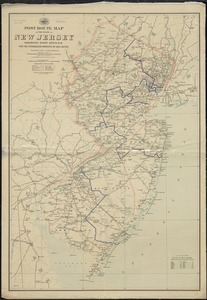
Post route map of the State of New Jersey showing post offices with the intermediate distances on mail routes in operation on...
57.
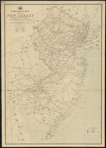
Post route map of the state of New Jersey showing post offices with the intermediate distances on mail routes in operation on...
58.
The principal part of the province of New Jersey shewing the road and distances to the several towns between the North River...
59.
Rand, McNally & Co.'s New Jersey
60.
Relief map of New Jersey
‹ Prev
Next ›
1
2
3
4
5
6
7
…
18
19