Toggle navigation
LMEC Home
Exhibitions
Georeferencing
Tools for Teachers
Collections
My Favorites
Sign Up / Log In
Search
Search the map portal
Map Collection
Map Collection
Map Sets
Search
Search
Search for
Search In
All Fields
Creator
Title
Subject
Place
Search All Digital Collections
Advanced Search
8185 Results
My Search
Start Over
More Like
commonwealth:x059cd487
Remove constraint More Like: commonwealth:x059cd487
Filter your Search
Place
North and Central America
4,922
United States
3,617
Suffolk (county)
1,026
Boston
999
Europe
963
Canada
428
France
269
Massachusetts
249
more
Place
»
Topic
Boston (Mass.)--Maps
574
United States--Maps
270
Real property--Massachusetts--Boston--Maps
174
Massachusetts--Maps
160
Landowners--Massachusetts--Boston--Maps
132
North America--Maps--Early works to 1800
105
New England--Maps
99
Europe--Maps
78
more
Topic
»
Date
Date range begin
–
Date range end
Current results range from
1482
to
2023
View distribution
Creator
United States. Hydrographic Office
357
O.H. Bailey & Co
148
Des Barres, Joseph F. W. (Joseph Frederick Wallet), 1722-1824
123
United States. Post Office Dept
120
Ptolemy, 2nd cent
100
Walling, Henry Francis, 1825-1888
94
Jefferys, Thomas, -1771
85
Geological Survey (U.S.)
82
more
Creator
»
Format
Maps/Atlases
8,126
Manuscripts
215
Prints
51
Books
36
Objects/Artifacts
10
Drawings/Illustrations
8
Posters
4
Georeferenced
Yes
869
No
7,316
Collection
Norman B. Leventhal Map Center Collection
8,162
Boston and New England Maps
2,184
Urban Maps
1,925
Maritime Charts and Atlases
750
American Revolutionary War-Era Maps
638
Boston Redevelopment Authority Collection
86
Richard H. Brown Revolutionary War Map Collection at Mount Vernon
10
Harvard Map Collection
3
more
Collection
»
Available to use
No known restrictions
8,024
Creative Commons license
64
Search Constraints
Sort by relevance
relevance
title
date (asc)
date (desc)
Number of results to display per page
50 per page
10
per page
20
per page
50
per page
100
per page
View results as:
grid view
map view
Search Results
1.
Theatre de la guerre en Amerique
2.
Théatre de la guerre en Amerique, avec les Isles Antilles : projetté et assujettie aux observations
3.
Théatre de la guerre en Amerique, avec les Isles Antilles : projetté et assujettie aux observations
4.
The theatre of war in North America, with the roads, and tables, of the superficial contents, distances, &ca
5.
Théatre de la guerre en Amerique, avec les Isles Antilles : projetté et assujettie aux observations
6.
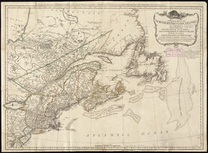
A general map of the northern British colonies in America : which comprehends the province of Quebec, the government of...
7.
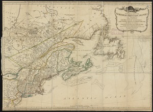
A general map of the northern British Colonies in America : which comprehends the province of Quebec, the government of...
8.
A new map of the British colonies in North America, shewing the seat of the present war, taken from the best surveys, compared...
9.
Boston, its environs and harbour, with the rebel works raised against that town in 1775 : from the observations of Lieut. Page...
10.
Boston with its environs
11.
Bowles's map of the seat of war in New England, comprehending the provinces of Massachusets Bay, and New Hampshire : with the...
12.
Carte des Etats-Unis de l'Amerique suivant le Traité de Paix de 1783
13.
Carte du théatre de la guerre entre les Anglais et les Américains
14.
A general map of the southern British colonies in America comprehending North and South Carolina, Georgia, East and West...
15.
Map for the interior travels through America, delineating the march of the army
16.
Partie de l'Amerique Septentrionale, qui comprend le Canada, la Louisiane, le Labrador, le Groenland, la Nouvelle Angleterre,...
17.
Plan der landung der Gebrüdere Howe, bey dem ausfluss des Elk Strom ...Lords Cornwallis
18.
Plan of the town of Boston, with the attack on Bunkers-Hill, in the peninsula of Charlestown, the 17th of June, 1775
19.
The provinces of New York and New Jersey : with part of Pensilvania, and the Province of Quebec
20.
Allgemeine charte von Nord America als den sitz des krieges zwischen den Konigl. Engl. truppen u:den provinzialen
21.
L'Amerique Septentrionale
22.
Carte de l'Amérique Septle. pour servir à l'intelligence de la guerre entre les Anglois et les insurgents
23.
Carte des Etats-Unis d'Amérique, et du cours du Mississippi : rédigée d'après différentes cartes et relations Anglaises et...
24.
Carte des Etats-Unis de l'Amerique suivant le Traité de Paix de 1783
25.
Carte générale des colonies Angloises : dans l'Amérique Septentrionale
26.
Carte generale des colonies angloises dans l'Amerique Septentrionale pour l'intelligence de la guerre presente : d'apres des...
27.
Carte generale des colonies angloises dans l'Amerique Septentrionale pour l'intelligence de la guerre presente : d'apres des...
28.
The Country twenty five miles round New York
29.
La Dominique située entre La Martinique et La Guadeloupe : conquise par M. le Mis. de Bouillé Marechal des camps et armées du...
30.
Karte von Neu England, Neu Yorck und Pensilvanien
31.
Map for the interior travels through America : delineating the march of the army
32.
A MAP of the BRITISH COLONIES in North America : WITH THE Roads, Distances, Limits, and Extent of the SETTLEMENTS, Humbly...
33.
A new and accurate map of the present seat of war in North America : from a late survey
34.
A new and correct map of North America : in which the places of the principal engagements during the present war are accurately...
35.
A new and correct map of North America : in which the places of the principal engagements during the present war are accurately...
36.
A plan of the attack made Nov.ber 27t. 1781 : by a detachment commanded by Brigadier-General Ross, from the Garrison of...
37.
A plan of the operations of the King's army under the command of General Sr. William Howe, K.B. in New York and east New...
38.
A plan of the surprise of Stoney Point, by a detachment of the American army commanded by Brigr. Genl. Wayne, on the 15th July...
39.
The seat of war, in New England, by an American volunteer : with the marches of the several corps sent by the colonies, towards...
40.
A sketch of Charleston Harbour : shewing the disposition of the British fleet under the command of Vice Adml. Mariot Arbuthnot...
41.
Suite du theatre de la guerre dans l'Amérique Septentrionale y compris le Golfe du Méxique
42.
The 100th anniversary map of Abraham Lincoln's visit to Massachusetts, September 11-23, 1848
43.
1630 shoreline
44.
1879. Progress map of the U.S. Geographical Surveys west of the 100th Meridian : prepared under the direction of 1st Lieut....
45.
1903 Map of Salem and surrounding places
46.
19th annual convention of the National Association of Real Estate Boards : at Tulsa, June 7 to June 11 in 1926
47.
2005 significant U.S. hurricane strikes
48.
The 2100 project : an atlas for the Green New Deal
49.
227 Harzgerode
50.
305 Glatz
‹ Prev
Next ›
1
2
3
4
5
…
163
164