Toggle navigation
LMEC Home
Exhibitions
Georeferencing
Tools for Teachers
Collections
My Favorites
Sign Up / Log In
Search
Search the map portal
Map Collection
Map Collection
Map Sets
Search
Search
Search for
Search In
All Fields
Creator
Title
Subject
Place
Search All Digital Collections
Advanced Search
8169 Results
My Search
Start Over
More Like
commonwealth:x059cc324
Remove constraint More Like: commonwealth:x059cc324
Filter your Search
Place
North and Central America
4,918
United States
3,608
Suffolk (county)
1,026
Boston
999
Europe
963
Canada
427
France
269
Massachusetts
250
more
Place
»
Topic
Boston (Mass.)--Maps
574
United States--Maps
270
Real property--Massachusetts--Boston--Maps
174
Massachusetts--Maps
160
Landowners--Massachusetts--Boston--Maps
132
North America--Maps--Early works to 1800
103
New England--Maps
99
Europe--Maps
78
more
Topic
»
Date
Date range begin
–
Date range end
Current results range from
1482
to
2023
View distribution
Creator
United States. Hydrographic Office
357
O.H. Bailey & Co
148
Des Barres, Joseph F. W. (Joseph Frederick Wallet), 1722-1824
123
United States. Post Office Dept
120
Ptolemy, 2nd cent
100
Walling, Henry Francis, 1825-1888
94
Jefferys, Thomas, -1771
84
Geological Survey (U.S.)
82
more
Creator
»
Format
Maps/Atlases
8,110
Manuscripts
215
Prints
51
Books
36
Objects/Artifacts
10
Drawings/Illustrations
8
Posters
4
Georeferenced
Yes
869
No
7,300
Collection
Norman B. Leventhal Map Center Collection
8,163
Boston and New England Maps
2,185
Urban Maps
1,926
Maritime Charts and Atlases
750
American Revolutionary War-Era Maps
616
Boston Redevelopment Authority Collection
86
Massachusetts Real Estate Atlases
6
Applied Geographics, Inc. Records
1
Available to use
No known restrictions
8,022
Creative Commons license
46
Search Constraints
Sort by relevance
relevance
title
date (asc)
date (desc)
Number of results to display per page
20 per page
10
per page
20
per page
50
per page
100
per page
View results as:
grid view
map view
Search Results
1.
Mount Auburn, avenues and paths
2.
Plan of the cemetery of Mount Auburn
3.
Plan of Mount Auburn
4.
Atlas of Middlesex County. Vol. 1. Cambridge, Somerville, Arlington, Belmont, Watertown, Everett, Malden, Medford, Newton,...
5.
Atlas of the towns of Watertown, Belmont, Arlington and Lexington, Middlesex County, Mass. : from official plans and actual...
6.
Historical map of Watertown, 1630-1930
7.
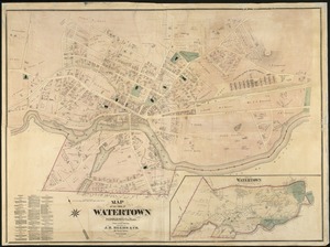
Map of the town of Watertown : Middlesex Co., Mass., from actual surveys
8.
Atlas of the city of Cambridge, Massachusetts : from actual surveys and official plans
9.
Atlas of the city of Cambridge, Massachusetts : from official records, private plan and actual surveys
10.
Atlas of the city of Cambridge, Massachusetts : from actual surveys and official plans
11.
Atlas of the city of Cambridge, Massachusetts : from actual surveys and official plans
12.
Atlas of the city of Cambridge, Massachusetts : from actual surveys and official plans
13.
Atlas of the city of Cambridge, Middlesex Co., Massachusetts
14.
Broad Canal, Cambridge : condition of retaining walls and bed of Canal, inspection for Committee on Charles River Dam, Oct. 30,...
15.
Compiled plan, showing Millers Creek and a portion of Charles River
16.
Insurance map of Charlestown : portions of Roxbury (now annexed to Boston) and Cambridge
17.
Insurance map of Charlestown : portions of Roxbury (now annexed to Boston) and Cambridge : 1868 : corrected Nov. 1871
18.
Insurance maps of Boston volume 4 : comprising portions of Charlestown, East Cambridge, Cambridge Port, Old Cambridge & Somerville
19.
Lechmere Canal, Cambridge : condition of retaining walls and bed of canal, inspection for Committee on Charles River Dam, Nov....
20.
Map of Cambridge
‹ Prev
Next ›
1
2
3
4
5
…
408
409