Toggle navigation
LMEC Home
Exhibitions
Georeferencing
Tools for Teachers
Collections
My Favorites
Sign Up / Log In
Search
Search the map portal
Map Collection
Map Collection
Map Sets
Search
Search
Search for
Search In
All Fields
Creator
Title
Subject
Place
Search All Digital Collections
Advanced Search
8721 Results
My Search
Start Over
More Like
commonwealth:wd376648f
Remove constraint More Like: commonwealth:wd376648f
Filter your Search
Place
North and Central America
5,952
United States
4,870
Massachusetts
2,103
Europe
1,396
Suffolk (county)
1,057
Boston
1,030
Canada
449
Asia
438
more
Place
»
Topic
Boston (Mass.)--Maps
596
United States--Maps
282
Real property--Massachusetts--Boston--Maps
175
Massachusetts--Maps
162
Landowners--Massachusetts--Boston--Maps
133
North America--Maps--Early works to 1800
103
New England--Maps
102
Europe--Maps
79
more
Topic
»
Date
Date range begin
–
Date range end
Current results range from
1482
to
2023
View distribution
Creator
United States. Hydrographic Office
595
O.H. Bailey & Co
148
Des Barres, Joseph F. W. (Joseph Frederick Wallet), 1722-1824
124
United States. Post Office Dept
120
Ptolemy, 2nd cent
100
Walling, Henry Francis, 1825-1888
94
Geological Survey (U.S.)
86
Jefferys, Thomas, -1771
85
more
Creator
»
Format
Maps/Atlases
8,661
Manuscripts
215
Prints
56
Books
36
Objects/Artifacts
10
Drawings/Illustrations
8
Posters
6
Georeferenced
Yes
872
No
7,849
Collection
Norman B. Leventhal Map & Education Center Collection
8,708
Boston and New England Maps
2,245
Urban Maps
2,027
Maritime Charts and Atlases
1,087
American Revolutionary War-Era Maps
627
Boston Redevelopment Authority Collection
89
Mapping Boston Collection
10
William L. Clements Library Collection
10
more
Collection
»
Available to use
No known restrictions
8,558
Creative Commons license
57
Search Constraints
Sort by relevance
relevance
title
date (asc)
date (desc)
Number of results to display per page
20 per page
10
per page
20
per page
50
per page
100
per page
View results as:
grid view
map view
Search Results
2021.
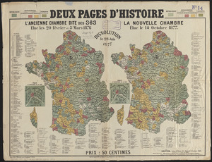
Deux pages d'histoire : l'ancienne Chambre dite des 363, elue les 20 Février et 5 Mars 1876, dissolution le 23 Juin 1877, la...
2022.
Devoniae descriptio : the description of Devonshire
2023.
Diagram of rail roads diverging from Boston : showing the depots and distances
2024.
Diagram of the Battle of Ball's Bluff
2025.
A diagram of the triangulation for the survey of the coast of the United States, made in 1817 and 1833, and the secondary...
2026.
Diagram of the United States of America, Mexico, the West India Islands and Isthmus of Darien : showing proposed routes of the...
2027.
Diagram showing the Changuinola Railroad lines
2028.
Diagram to illustrate contrast between British and Chinese Empires
2029.
A diagrammatic road map of Central Europe : for the use of automobilists and cyclists
2030.
Dinsmore's complete map of the railroads & canals in the United States & Canada
2031.
Dinsmore's complete map of the railroads & canals in the United States & Canada
2032.
Dinsmore's new railroad map of the United States and the Canadas, showing all the railroads completed and in progress,...
2033.
Diocèse de Castres, dédié à Messire Augustin de Maupeou, Conseiller du Roy en ses Conseils Evêque de Castres
2034.
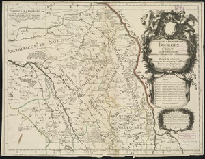
Diocese de l'archevesche de Bourges
2035.
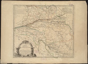
Diocese de l'archevesché de Tours : La Touraine : Les Eslections de Tours, d'Amboise, de Loches, et de Chinon
2036.
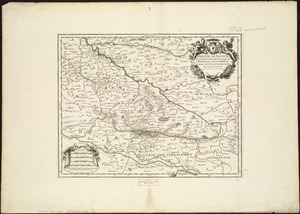
Diocese de Lavaur descrit par ordre de Monseigneur l'illustrissime et reverendissime Charles Le Goux de Laberchere Evesque de...
2037.
Le Diocese de Limoges : divisé en ses dix huict Archipretré et les Gouvernemens de la Marche et du Limosin dans les quels il...
2038.
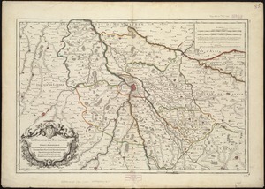
Diocese de Nismes
2039.
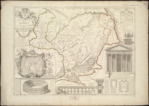
Le Diocese de Toulouse
2040.
Diocese du Mans divisee par doyennes ruraux
‹ Prev
Next ›
1
2
…
98
99
100
101
102
103
104
105
106
…
436
437