Toggle navigation
LMEC Home
Exhibitions
Georeferencing
Tools for Teachers
Collections
My Favorites
Sign Up / Log In
Search
Search the map portal
Map Collection
Map Collection
Map Sets
Search
Search
Search for
Search In
All Fields
Creator
Title
Subject
Place
Search All Digital Collections
Advanced Search
8247 Results
My Search
Start Over
More Like
commonwealth:q524n3851
Remove constraint More Like: commonwealth:q524n3851
Filter your Search
Place
North and Central America
4,934
United States
3,614
Suffolk (county)
1,026
Boston
999
Europe
963
Canada
437
North America
301
France
269
more
Place
»
Topic
Boston (Mass.)--Maps
574
United States--Maps
270
North America--Maps--Early works to 1800
180
Real property--Massachusetts--Boston--Maps
174
Massachusetts--Maps
160
Landowners--Massachusetts--Boston--Maps
132
New England--Maps
99
Europe--Maps
78
more
Topic
»
Date
Date range begin
–
Date range end
Current results range from
1482
to
2023
View distribution
Creator
United States. Hydrographic Office
357
O.H. Bailey & Co
148
Des Barres, Joseph F. W. (Joseph Frederick Wallet), 1722-1824
123
United States. Post Office Dept
120
Ptolemy, 2nd cent
100
Walling, Henry Francis, 1825-1888
94
Jefferys, Thomas, -1771
92
Sayer, Robert, 1725-1794
84
more
Creator
»
Format
Maps/Atlases
8,188
Manuscripts
220
Prints
51
Books
36
Objects/Artifacts
10
Drawings/Illustrations
8
Posters
4
Georeferenced
Yes
872
No
7,375
Collection
Norman B. Leventhal Map Center Collection
8,172
Boston and New England Maps
2,185
Urban Maps
1,925
Maritime Charts and Atlases
750
American Revolutionary War-Era Maps
685
Boston Redevelopment Authority Collection
86
New York Public Library Collection
32
Richard H. Brown Revolutionary War Map Collection at Mount Vernon
19
more
Collection
»
Available to use
No known restrictions
8,025
Creative Commons license
113
Search Constraints
Sort by relevance
relevance
title
date (asc)
date (desc)
Number of results to display per page
20 per page
10
per page
20
per page
50
per page
100
per page
View results as:
grid view
map view
Search Results
7541.
The theatre of war in North America, with the roads, and tables, of the superficial contents, distances, &ca
7542.
These United States : products & industries
7543.
Thirteenth Amendment, January 31, 1865, Vote on passage of resolution submitting
7544.
Thirty-miles round Boston
7545.
This harbour of Boston
7546.
This harbour of Boston
7547.
This map of Scotland
7548.
This map of South America, according to the newest and most exact observations
7549.
This map presents a Bostonian's idea of the United States of America
7550.
This plan contains about 1000 acres, of the Canton Company's Land
7551.
This plan of the city of Philadelphia and it's [sic] environs, (shewing the improved parts,) is dedicated to the mayor,...
7552.
Three Rivers, Mass
7553.
Thunder Bay, Lake Huron
7554.
Thun-Interlaken
7555.
Tilton, N.H., Belknap County : 1884
7556.
The Times-Picayune's map of New Orleans
7557.
Title page of Theatrum Orbis Terrarum
7558.
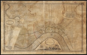
To General Andrew Jackson and his brave companions in arms on the 8th of Jany. 1815 this plan of the city of New Orleans is...
7559.
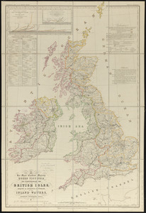
To her most excellent majesty Queen Victoria this hydrographical map of the British Isles, exhibiting the geographical...
7560.
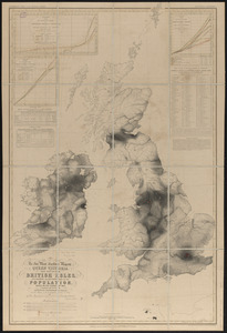
To her most excellent majesty Queen Victoria this map of the British Isles, elucidating the distribution of the population,...
‹ Prev
Next ›
1
2
…
374
375
376
377
378
379
380
381
382
…
412
413


![This plan of the city of Philadelphia and it's [sic] environs, (shewing the improved parts,) is dedicated to the mayor, aldermen and citizens thereof](https://bpldcassets.blob.core.windows.net/derivatives/images/commonwealth:4m90fd11j/image_thumbnail_300.jpg)