Toggle navigation
LMEC Home
Exhibitions
Georeferencing
Tools for Teachers
Collections
My Favorites
Sign Up / Log In
Search
Search the map portal
Map Collection
Map Collection
Map Sets
Search
Search
Search for
Search In
All Fields
Creator
Title
Subject
Place
Search All Digital Collections
Advanced Search
376 Results
My Search
Start Over
More Like
commonwealth:hx11z170b
Remove constraint More Like: commonwealth:hx11z170b
Filter your Search
Place
North and Central America
335
United States
209
Canada
103
Essex (county)
24
Louisbourg
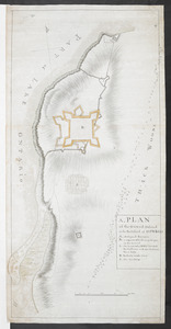
21
Saint Lawrence River
19
Suffolk (county)
16
Warren (county)
16
more
Place
»
Topic
United States--History--French and Indian War, 1754-1763--Maps, Manuscript--Early works to 1800
58
Louisbourg (N.S.)--Maps, Manuscript--Early works to 1800
18
Fort Edward (N.Y.)--Maps, Manuscript--Early works to 1800
15
Fort Ticonderoga (N.Y.)--Maps, Manuscript--Early works to 1800
15
Saint Lawrence River--Maps, Manuscript--Early works to 1800
15
Louisbourg (N.S.)--History--Siege, 1745--Maps, Manuscript--Early works to 1800
14
Fortification--New York (State)--Maps, Manuscript--Early works to 1800
13
Fortification--New York (State)--Fort Edward--Maps, Manuscript--Early works to 1800
12
more
Topic
»
Date
Date range begin
–
Date range end
Current results range from
1664
to
1816
View distribution
Creator
Royal United Services Institute for Defence and Security Studies
159
George, III, King of Great Britain, 1738-1820
152
George, IV, King of Great Britain, 1762-1830
151
Amherst, Jeffery Amherst, Baron, 1717-1797
127
Skinner, Monier
28
Skinner, William, 1700-1780
28
Brasier, William
16
Bastide, John Henry, approximately 1700-1770
15
more
Creator
»
Format
Maps/Atlases
359
Manuscripts
150
Drawings/Illustrations
15
Georeferenced
Yes
7
No
369
Collection
British Library Collection
376
American Revolutionary War-Era Maps
352
Boston and New England Maps
21
Urban Maps
5
Maritime Charts and Atlases
2
Available to use
Creative Commons license
376
Search Constraints
Sort by relevance
relevance
title
date (asc)
date (desc)
Number of results to display per page
50 per page
10
per page
20
per page
50
per page
100
per page
View results as:
grid view
map view
Search Results
1.
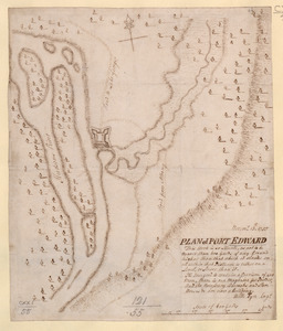
Fort Edward
2.
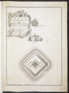
PLAN ELEVATION SECTION and PROFILE of ye ROYAL BLOCKHOUSE OPPOSITE FORT EDWARD
3.
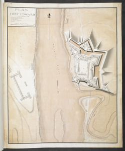
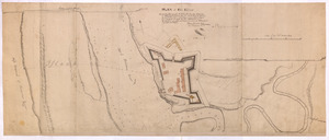
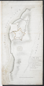
PLAN FORT EDWARD
4.
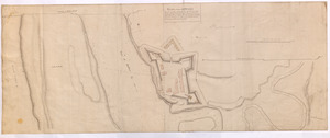
PLAN of FORT EDWARD
5.
PLAN of Fort Edward
6.
PLAN of Fort EDWARD
7.
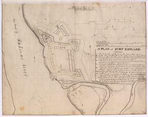
A PLAN of FORT EDWARD
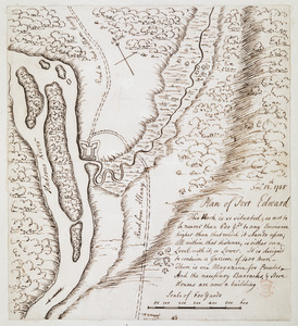
8.
Plan of Fort Edward
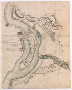
9.
Plan of the Environs of Fort Edward
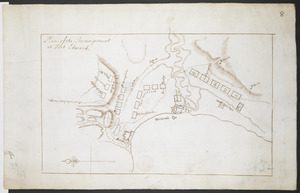
10.
Plan of the Incampement at Fort Edward
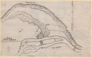
11.
Sketch of Fort Edward and the proposed improvements
12.
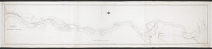
PART OF HUDSON'S RIVER
13.
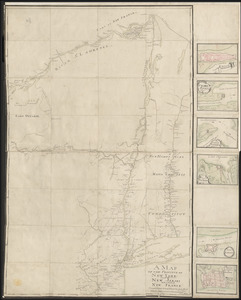
A MAP OF THE PROVINCE OF NEW-YORK, PART OF NEW JERSEY with a Part of NEW FRANCE Composed from Actual Surveys
14.
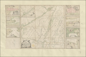
PLAN of the COUNTRY from FORT EDWARD to CROWN POINT
15.
TO HIS EXCELLENCY MAJOR GENERAL ABERCROMBIE COLONEL OF THE 44TH REG:T OF FOOT CO: IN CHIEF OF THE ROYAL AMERICAN REG: &...
16.
1.r Plan du fort proposé dans l'Ille de S.t Simon pour la deffence de l'Entree du Havre de Jenkins Sownd
17.
1.r Plan du fort proposé dans l'Ille de S.t Simon pour la deffence de l'Entree du Havre de Jenkins Sownd
18.
1:st Position
19.
2:d Position
20.
2.e Plan d'une Batterie & d'une Redoute avec un Corps de Garde construit en forme de Redoute a Machecoulis pour y Servir de...
21.
3:d Position
22.
4:th Position
23.
[A colored map of the route between Albany and Oswego; drawn about 1756, on a scale of 2 miles to an inch]
24.
[A coloured chart of the upper part of Lake Erie at Fort Erie and a detailed plan of Fort Erie, together with three cross...
25.
A= draught of Boston Harbor
26.
[A manuscript map of Isle Royalle]
27.
[A map of Fort Carillon and environs]
28.
[A map of Fort Carillon and environs]
29.
[A map of Lake Champlain and Lake George, showing the route from Fort Edward to Montreal]
30.
[A map of Lake Erie with the route southward from Fort Presqu'Isle to Fort Cumberland, with inset plans of Fort Pitt, Fort...
31.
[A map of Lake George from Fort William Henry to Ticonderoga]
32.
[A map of Nova Scotia showing the post roads]
33.
[A map of part of New York, comprehending the country between New York and Quebec, the river Connecticut, &c., to shew "the way...
34.
[A map of part of New York, comprehending the country between New York and Quebec, the river Connecticut, &c., to shew "the way...
35.
[A map of the east coast of America from Newfoundland to the Bay of Honduras]
36.
[A map of the River Schohary with a plan and elevation of the new fort]
37.
[A map of the southern part of the Lake Champlain, from "Tienderoga fort" to Crown Point]
38.
[A map showing the northern part of Lake George and Fort Ticonderoga]
39.
[A map showing the post route between the River St. Lawrence and the Bay of Fundy] : [on a scale of 5 1/3 miles to an inch.]
40.
[A map showing the post route between the River St. Lawrence and the Bay of Fundy] : [on a scale of 5 1/3 miles to an inch.]
41.
A, PLAN of the Ground Defined to be Fortified at OSWEGO
42.
A, PLAN of the Ground Defined to be Fortified at OSWEGO
43.
[A sketch map of the proposed battery (?) on Jekyll Island (?)]
44.
[Acadie, Isle Saint Jean and part of Isle Royale with the Baye Francoise]
45.
[Account of the action at Fort Niagara]
46.
[An outline plan of the harbour and fortifications of Louisbourg]
47.
[An unfinished chart of the Saint Lawrence River from Perrot Island to the Island of Orleans]
48.
BOWLES'S NEW POCKET MAP OF THE UNITED STATES OF AMERICA : WITH THE BRITISH POSSESSIONS OF CANADA, NOVA SCOTIA, AND OF...
49.
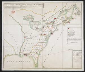
CANTONMENT of HIS MAJESTY'S FORCES in N. AMERICA ACCORDING TO THE DISPOSITION NOW MADE & TO BE COMPLETED AS SOON AS PRACTICABLE...
50.
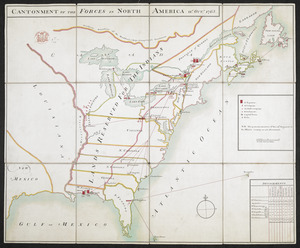
CANTONMENT OF THE FORCES IN NORTH AMERICA 11.th OCT.R 1765
‹ Prev
Next ›
1
2
3
4
5
…
7
8


![[A colored map of the route between Albany and Oswego; drawn about 1756, on a scale of 2 miles to an inch]](https://bpldcassets.blob.core.windows.net/derivatives/images/commonwealth:hx11z3223/image_thumbnail_300.jpg)
![[A coloured chart of the upper part of Lake Erie at Fort Erie and a detailed plan of Fort Erie, together with three cross sectional drawings]](https://bpldcassets.blob.core.windows.net/derivatives/images/commonwealth:hx11z482r/image_thumbnail_300.jpg)

![[A manuscript map of Isle Royalle]](https://bpldcassets.blob.core.windows.net/derivatives/images/commonwealth:hx11z507d/image_thumbnail_300.jpg)
![[A map of Fort Carillon and environs]](https://bpldcassets.blob.core.windows.net/derivatives/images/commonwealth:hx11z538d/image_thumbnail_300.jpg)
![[A map of Fort Carillon and environs]](https://bpldcassets.blob.core.windows.net/derivatives/images/commonwealth:hx11z342k/image_thumbnail_300.jpg)
![[A map of Lake Champlain and Lake George, showing the route from Fort Edward to Montreal]](https://bpldcassets.blob.core.windows.net/derivatives/images/commonwealth:hx11z3312/image_thumbnail_300.jpg)
![[A map of Lake Erie with the route southward from Fort Presqu'Isle to Fort Cumberland, with inset plans of Fort Pitt, Fort Venango, Fort Le Boeuf and Fort Presque Isle]](https://bpldcassets.blob.core.windows.net/derivatives/images/commonwealth:6108vw18h/image_thumbnail_300.jpg)
![[A map of Lake George from Fort William Henry to Ticonderoga]](https://bpldcassets.blob.core.windows.net/derivatives/images/commonwealth:hx11z3380/image_thumbnail_300.jpg)
![[A map of Nova Scotia showing the post roads]](https://bpldcassets.blob.core.windows.net/derivatives/images/commonwealth:hx11z494j/image_thumbnail_300.jpg)
![[A map of part of New York, comprehending the country between New York and Quebec, the river Connecticut, &c., to shew "the way from Albany to Canada ..... part by land and part by water;" drawn about 1720, on a scale of 31 miles to an inch]](https://bpldcassets.blob.core.windows.net/derivatives/images/commonwealth:6108vw070/image_thumbnail_300.jpg)
![[A map of part of New York, comprehending the country between New York and Quebec, the river Connecticut, &c., to shew "the way from Albany to Canada ..... part by land and part by water;" drawn about 1720, on a scale of 31 miles to an inch]](https://bpldcassets.blob.core.windows.net/derivatives/images/commonwealth:6108vw09j/image_thumbnail_300.jpg)
![[A map of the east coast of America from Newfoundland to the Bay of Honduras]](https://bpldcassets.blob.core.windows.net/derivatives/images/commonwealth:hx11z584h/image_thumbnail_300.jpg)
![[A map of the River Schohary with a plan and elevation of the new fort]](https://bpldcassets.blob.core.windows.net/derivatives/images/commonwealth:hx11z356x/image_thumbnail_300.jpg)
![[A map of the southern part of the Lake Champlain, from "Tienderoga fort" to Crown Point]](https://bpldcassets.blob.core.windows.net/derivatives/images/commonwealth:6108vv78r/image_thumbnail_300.jpg)
![[A map showing the northern part of Lake George and Fort Ticonderoga]](https://bpldcassets.blob.core.windows.net/derivatives/images/commonwealth:hx11z3444/image_thumbnail_300.jpg)
![[A map showing the post route between the River St. Lawrence and the Bay of Fundy]](https://bpldcassets.blob.core.windows.net/derivatives/images/commonwealth:hx11z4963/image_thumbnail_300.jpg)
![[A map showing the post route between the River St. Lawrence and the Bay of Fundy]](https://bpldcassets.blob.core.windows.net/derivatives/images/commonwealth:hx11z498n/image_thumbnail_300.jpg)
![[A sketch map of the proposed battery (?) on Jekyll Island (?)]](https://bpldcassets.blob.core.windows.net/derivatives/images/commonwealth:hx11z460q/image_thumbnail_300.jpg)
![[Acadie, Isle Saint Jean and part of Isle Royale with the Baye Francoise]](https://bpldcassets.blob.core.windows.net/derivatives/images/commonwealth:hx11z490f/image_thumbnail_300.jpg)
![[Account of the action at Fort Niagara]](https://bpldcassets.blob.core.windows.net/derivatives/images/commonwealth:6108vv66z/image_thumbnail_300.jpg)
![[An outline plan of the harbour and fortifications of Louisbourg]](https://bpldcassets.blob.core.windows.net/derivatives/images/commonwealth:hx11z5128/image_thumbnail_300.jpg)
![[An unfinished chart of the Saint Lawrence River from Perrot Island to the Island of Orleans]](https://bpldcassets.blob.core.windows.net/derivatives/images/commonwealth:hx11z0836/image_thumbnail_300.jpg)