Toggle navigation
LMEC Home
Exhibitions
Georeferencing
Tools for Teachers
Collections
My Favorites
Sign Up / Log In
Search
Search the map portal
Map Collection
Map Collection
Map Sets
Search
Search
Search for
Search In
All Fields
Creator
Title
Subject
Place
Search All Digital Collections
Advanced Search
91 Results
My Search
Start Over
More Like
commonwealth:hq37vv92f
Remove constraint More Like: commonwealth:hq37vv92f
Filter your Search
Place
North and Central America
48
New England
20
United States
20
Massachusetts
17
Rhode Island
8
New York
7
Connecticut
6
Middle Atlantic
6
more
Place
»
Topic
New England--Maps--Early works to 1800
15
World maps--Early works to 1800
13
America--Maps--Early works to 1800
9
Massachusetts--Maps
8
North America--Maps--Early works to 1800
8
Western Hemisphere--Maps--Early works to 1800
6
Connecticut--Maps--Early works to 1800
5
Massachusetts--Maps--Early works to 1800
5
more
Topic
»
Date
Date range begin
–
Date range end
Current results range from
1482
to
1990
View distribution
Creator
Ortelius, Abraham, 1527-1598
5
Bew, John, -1793
3
Bordon, Benedetto, 1450-1530
3
Gastaldi, Giacomo, approximately 1500-approximately 1565
3
Hondius, Jodocus, 1594 or 1595-1629
3
Lodge, John, -1796
3
Mercator, Gerhard, 1512-1594
3
Münster, Sebastian, 1489-1552
3
more
Creator
»
Format
Maps/Atlases
91
Books
1
Georeferenced
Yes
9
No
82
Collection
Sidney R. Knafel Map Collection at Phillips Academy
87
American Revolutionary War-Era Maps
25
Boston and New England Maps
4
Maritime Charts and Atlases
4
Norman B. Leventhal Map Center Collection
4
Available to use
No known restrictions
4
Search Constraints
Sort by date (desc)
relevance
title
date (asc)
date (desc)
Number of results to display per page
20 per page
10
per page
20
per page
50
per page
100
per page
View results as:
grid view
map view
Search Results
1.
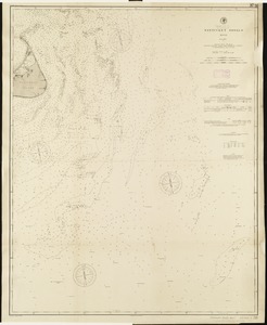
Nantucket Shoals, Mass
2.
Sketch A showing the progress of the survey in section no. 1 from 1844 to 1881
3.
Chart of the Vineyard Sound and Nantucket Shoals
4.
Old Colony Railroad and connections
5.
Barnstable County, Dukes County and Nantucket Island, Massachusetts
6.
Old Colony & Newport railway and its connections
7.
Massachusetts and Rhode Island
8.
Sketch A No. 5 showing proposed site for a light house on Sow and Pigs Reef
9.
Preliminary sketch showing the positions of Davis's Shoal and other dangers recently discovered by the Coast Survey and the...
10.
The harbor of Holmes' Hole
11.
Massachusetts
12.
Massachusetts
13.
Geological map of Massachusetts
14.
Map of the northern part of New England : compiled for Pres't. Dwight's travels
15.
Map of the southern part of New England : compiled for Pres't. Dwights travels
16.
The state of Massachusetts
17.
A new chart of Nantucket Shoals & George's Bank with the adjacent coast
18.
Map of Massachusetts, from the best authorities
19.
The American pilot : containing the navigation of the sea coat of North America . . .
20.
Massachusetts
‹ Prev
Next ›
1
2
3
4
5