Toggle navigation
LMEC Home
Exhibitions
Georeferencing
Tools for Teachers
Collections
My Favorites
Sign Up / Log In
Search
Search the map portal
Map Collection
Map Collection
Map Sets
Search
Search
Search for
Search In
All Fields
Creator
Title
Subject
Place
Search All Digital Collections
Advanced Search
8769 Results
My Search
Start Over
More Like
commonwealth:cj82m2577
Remove constraint More Like: commonwealth:cj82m2577
Filter your Search
Place
North and Central America
5,997
United States
4,917
Massachusetts
2,083
Europe
1,396
Suffolk (county)
1,048
Boston
1,021
Canada
470
Asia
438
more
Place
»
Topic
Boston (Mass.)--Maps
588
United States--Maps
330
Real property--Massachusetts--Boston--Maps
175
Massachusetts--Maps
164
Landowners--Massachusetts--Boston--Maps
133
New England--Maps
127
North America--Maps--Early works to 1800
103
Europe--Maps
79
more
Topic
»
Date
Date range begin
–
Date range end
Current results range from
1482
to
2023
View distribution
Creator
United States. Hydrographic Office
595
O.H. Bailey & Co
148
Des Barres, Joseph F. W. (Joseph Frederick Wallet), 1722-1824
123
United States. Post Office Dept
120
Ptolemy, 2nd cent
100
Walling, Henry Francis, 1825-1888
94
Geological Survey (U.S.)
87
Jefferys, Thomas, -1771
86
more
Creator
»
Format
Maps/Atlases
8,709
Manuscripts
215
Prints
56
Books
36
Objects/Artifacts
10
Drawings/Illustrations
8
Posters
5
Georeferenced
Yes
873
No
7,896
Collection
Norman B. Leventhal Map & Education Center Collection
8,704
Boston and New England Maps
2,239
Urban Maps
2,023
Maritime Charts and Atlases
1,083
American Revolutionary War-Era Maps
674
Boston Redevelopment Authority Collection
87
Maps from AAS
29
William L. Clements Library Collection
16
more
Collection
»
Available to use
No known restrictions
8,560
Creative Commons license
53
Search Constraints
Sort by relevance
relevance
title
date (asc)
date (desc)
Number of results to display per page
20 per page
10
per page
20
per page
50
per page
100
per page
View results as:
grid view
map view
Search Results
3641.
Map, boundary, Michigan and Ohio
3642.
Map City of Baltimore
3643.
A map containing the towns, villages, gentlemens houses, roads, rivers & other remarks for 20 miles round London
3644.
[Map depicting early land division and ownership in Barnard, Vermont]
3645.
Map eighth division railway mail service
3646.
Map eleventh division railway mail service
3647.
A map exhibiting a general view of the roads and inland navigation of Pennsylvania, and part of the adjacent states :...
3648.
Map exhibiting the country between Lakes Michigan and Erie, and the contested boundary lines
3649.
Map exhibiting the Farmington & Hampshire & Hampden canals : together with the line of their proposed continuation through the...
3650.
Map, exhibiting the position of the several lines connected with the settlement of the Ohio boundary question
3651.
Map fifth division railway mail service
3652.
Map for the interior travels through America, delineating the march of the army
3653.
Map fourth division railway mail service
3654.
Map from the Pacific Ocean across the Rocky Mountain zone : to accompany report on the exploratory survey
3655.
Map illustrating the defence [sic] of Savannah, Ga. and the operations resulting in its capture by the army commanded by Maj....
3656.
Map illustrating the distribution of some of the more important trees in British Columbia
3657.
Map illustrating the military operations in front of Atlanta, Ga : from the passage of Peach Tree Creek, July 19th, 1864, to...
3658.
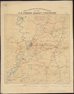
Map illustrating the operations of U.S. Forces against Vicksburg
3659.
Map illustrating the siege of Atlanta, Ga. by the U.S. forces, under command of Maj. Gen. W.T. Sherman : from the passage of...
3660.
Map New England
‹ Prev
Next ›
1
2
…
179
180
181
182
183
184
185
186
187
…
438
439


![[Map depicting early land division and ownership in Barnard, Vermont]](https://bpldcassets.blob.core.windows.net/derivatives/images/commonwealth:kk91ft09h/image_thumbnail_300.jpg)


![Map illustrating the defence [sic] of Savannah, Ga. and the operations resulting in its capture by the army commanded by Maj. Genl. W.T. Sherman, Dec. 21st, 1864](https://bpldcassets.blob.core.windows.net/derivatives/images/commonwealth:4m90f544n/image_thumbnail_300.jpg)