Toggle navigation
LMEC Home
Exhibitions
Georeferencing
Tools for Teachers
Collections
My Favorites
Sign Up / Log In
Search
Search the map portal
Map Collection
Map Collection
Map Sets
Search
Search
Search for
Search In
All Fields
Creator
Title
Subject
Place
Search All Digital Collections
Advanced Search
8169 Results
My Search
Start Over
More Like
commonwealth:9s161965p
Remove constraint More Like: commonwealth:9s161965p
Filter your Search
Place
North and Central America
4,918
United States
3,608
Suffolk (county)
1,031
Boston
1,004
Europe
963
Canada
427
France
269
Massachusetts
249
more
Place
»
Topic
Boston (Mass.)--Maps
574
United States--Maps
270
Real property--Massachusetts--Boston--Maps
174
Massachusetts--Maps
160
Landowners--Massachusetts--Boston--Maps
132
North America--Maps--Early works to 1800
103
New England--Maps
99
Europe--Maps
78
more
Topic
»
Date
Date range begin
–
Date range end
Current results range from
1482
to
2023
View distribution
Creator
United States. Hydrographic Office
357
O.H. Bailey & Co
148
Des Barres, Joseph F. W. (Joseph Frederick Wallet), 1722-1824
123
United States. Post Office Dept
120
Ptolemy, 2nd cent
100
Walling, Henry Francis, 1825-1888
94
Jefferys, Thomas, -1771
85
Geological Survey (U.S.)
82
more
Creator
»
Format
Maps/Atlases
8,110
Manuscripts
217
Prints
51
Books
36
Objects/Artifacts
10
Drawings/Illustrations
8
Posters
4
Georeferenced
Yes
869
No
7,300
Collection
Norman B. Leventhal Map Center Collection
8,162
Boston and New England Maps
2,185
Urban Maps
1,924
Maritime Charts and Atlases
750
American Revolutionary War-Era Maps
621
Boston Redevelopment Authority Collection
86
British Library Collection
5
Library of Congress Collection
2
Available to use
No known restrictions
8,021
Creative Commons license
53
Search Constraints
Sort by relevance
relevance
title
date (asc)
date (desc)
Number of results to display per page
20 per page
10
per page
20
per page
50
per page
100
per page
View results as:
grid view
map view
Search Results
1.
Plan de Boston
2.
[Plan of Boston neck]
3.
A= draught of Boston Harbor
4.
[Boston Harbour, with the surroundings, &c]
5.
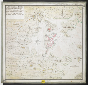
A DRAUGHT of the TOWNS of BOSTON and CHARLES TOWN and the Circumjacent Country shewing the Works thrown up by His MAJESTY'S...
6.
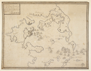
An Exact Draught of Bostone harbour, with a Survey of most of the Islands about it
7.
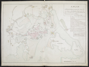
A PLAN of BOSTON and its Environs shewing the true Situation of His Majesty's Troops, and also those of the Rebels; likewise...
8.
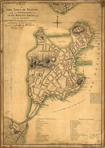
A plan of the town of Boston with the intrenchments &ca. of His Majesty's forces in 1775 : from the observations of Lieut. Page...
9.
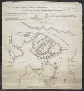
A SKETCH OF THE ACTION BETWEEN THE BRITISH FORCES AND THE AMERICAN PROVINCIALS, on the Heights of the Peninsula of Charlestown,...
10.
The 100th anniversary map of Abraham Lincoln's visit to Massachusetts, September 11-23, 1848
11.
1630 shoreline
12.
1879. Progress map of the U.S. Geographical Surveys west of the 100th Meridian : prepared under the direction of 1st Lieut....
13.
1903 Map of Salem and surrounding places
14.
19th annual convention of the National Association of Real Estate Boards : at Tulsa, June 7 to June 11 in 1926
15.
2005 significant U.S. hurricane strikes
16.
The 2100 project : an atlas for the Green New Deal
17.
227 Harzgerode
18.
305 Glatz
19.
38,000,000 escaped -- 10,000,000 died
20.
4 Kinten
‹ Prev
Next ›
1
2
3
4
5
…
408
409
![[Plan of Boston neck]](https://bpldcassets.blob.core.windows.net/derivatives/images/commonwealth:9s161g52n/image_thumbnail_300.jpg)

![[Boston Harbour, with the surroundings, &c]](https://bpldcassets.blob.core.windows.net/derivatives/images/commonwealth:t722hs94d/image_thumbnail_300.jpg)