Toggle navigation
LMEC Home
Exhibitions
Georeferencing
Tools for Teachers
Collections
My Favorites
Sign Up / Log In
Search
Search the map portal
Map Collection
Map Collection
Map Sets
Search
Search
Search for
Search In
All Fields
Creator
Title
Subject
Place
Search All Digital Collections
Advanced Search
8162 Results
My Search
Start Over
More Like
commonwealth:9g54xm249
Remove constraint More Like: commonwealth:9g54xm249
Filter your Search
Place
North and Central America
4,911
United States
3,602
Suffolk (county)
1,026
Boston
999
Europe
963
Canada
426
France
269
Massachusetts
249
more
Place
»
Topic
Boston (Mass.)--Maps
574
United States--Maps
270
Real property--Massachusetts--Boston--Maps
174
Massachusetts--Maps
160
Landowners--Massachusetts--Boston--Maps
132
North America--Maps--Early works to 1800
103
New England--Maps
99
Europe--Maps
78
more
Topic
»
Date
Date range begin
–
Date range end
Current results range from
1482
to
2023
View distribution
Creator
United States. Hydrographic Office
357
O.H. Bailey & Co
148
Des Barres, Joseph F. W. (Joseph Frederick Wallet), 1722-1824
122
United States. Post Office Dept
120
Ptolemy, 2nd cent
100
Walling, Henry Francis, 1825-1888
94
Jefferys, Thomas, -1771
84
Geological Survey (U.S.)
82
more
Creator
»
Format
Maps/Atlases
8,103
Manuscripts
215
Prints
51
Books
36
Objects/Artifacts
10
Drawings/Illustrations
8
Posters
4
Georeferenced
Yes
869
No
7,293
Collection
Norman B. Leventhal Map Center Collection
8,162
Boston and New England Maps
2,184
Urban Maps
1,925
Maritime Charts and Atlases
749
American Revolutionary War-Era Maps
615
Boston Redevelopment Authority Collection
86
Available to use
No known restrictions
8,021
Creative Commons license
46
Search Constraints
Sort by date (desc)
relevance
title
date (asc)
date (desc)
Number of results to display per page
20 per page
10
per page
20
per page
50
per page
100
per page
View results as:
grid view
map view
Search Results
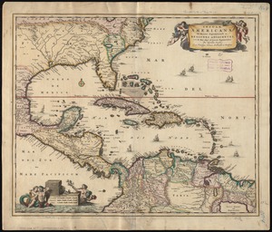
7461.
Insulæ Americanæ in Oceano Septentrionali ac regiones adiacentes : a C. de May usque ad Lineam Æquinoctialem
7462.
A map of Canaan : with the adjacent countrie's very usefull for the understanding of the Old Testament
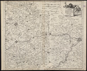
7463.
A new mapp of ye seat of the warr in the counties of Namur and Hainault wherin perticulerly is described ye cittyes town's...
7464.
Ævi veteris usque ad annum salutis nonagesimum supra milles quadringentos cogniti tantum, typus geographica
7465.
America Settentrionale : colle nuove scoperte fin alle' anno 1688 divisa nelle sue partu secondo lo stato presente
7466.
Amerique meridionale divisée en ses principales parties ou sont distingués les vns des autres les estats suivant qu'ils...
7467.
Corso del fiume dell Amazon
7468.
Haute et Basse Alsace, Suntgaw, Brisgaw, Ortenaw et le Marquisat de Bade, avec les divers Routes et Passages des Montagnes et...
7469.
Mare del Nord
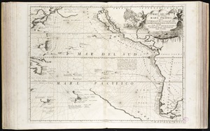
7470.
Mare del Svd, detto altrimenti Mare Pacifico
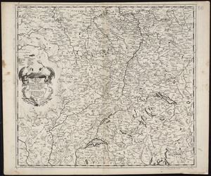
7471.
A new mapp of the upper part of the Rhine containing all Switzerland the circle of Swabia Alsatia the Palatine of the Rhine...
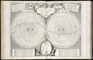
7472.
Planisferii celesti, calcolati per l'anno MDCC, corretti, et aumentati di molte stelle, ad uso dell' Accademia Cosmografica...
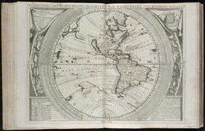
7473.
Planisfero del mondo nuovo
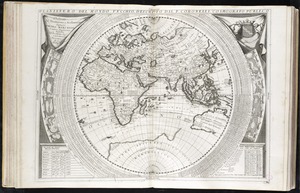
7474.
Planisfero del mondo vecchio
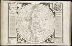
7475.
Planisfero meridionale, corretto, et accresciuto di molte stelle calcolato all' epoca dell' anno 1700
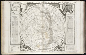
7476.
Planisfero settentrionale, corretto, et accresciuto di molte stelle calcolato all' epoca dell' anno 1700
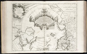
7477.
Terre Artiche
7478.
An alphabetical table of all the cities, towns, villages and all other places of merit in the Kingdom of France, & circumjacent...
7479.
Americae nova discriptio
7480.
Archiepiscopatus Trevirensis recentissima delineatio
‹ Prev
Next ›
1
2
…
370
371
372
373
374
375
376
377
378
…
408
409