Toggle navigation
LMEC Home
Exhibitions
Georeferencing
Tools for Teachers
Collections
My Favorites
Sign Up / Log In
Search
Search the map portal
Map Collection
Map Collection
Map Sets
Search
Search
Search for
Search In
All Fields
Creator
Title
Subject
Place
Search All Digital Collections
Advanced Search
8164 Results
My Search
Start Over
More Like
commonwealth:9g54xk286
Remove constraint More Like: commonwealth:9g54xk286
Filter your Search
Place
North and Central America
4,913
United States
3,603
Suffolk (county)
1,026
Boston
999
Europe
963
Canada
427
France
269
Massachusetts
249
more
Place
»
Topic
Boston (Mass.)--Maps
574
United States--Maps
270
Real property--Massachusetts--Boston--Maps
174
Massachusetts--Maps
160
Landowners--Massachusetts--Boston--Maps
132
North America--Maps--Early works to 1800
103
New England--Maps
99
Europe--Maps
78
more
Topic
»
Date
Date range begin
–
Date range end
Current results range from
1482
to
2023
View distribution
Creator
United States. Hydrographic Office
357
O.H. Bailey & Co
148
Des Barres, Joseph F. W. (Joseph Frederick Wallet), 1722-1824
123
United States. Post Office Dept
120
Ptolemy, 2nd cent
100
Walling, Henry Francis, 1825-1888
94
Jefferys, Thomas, -1771
84
Geological Survey (U.S.)
82
more
Creator
»
Format
Maps/Atlases
8,105
Manuscripts
215
Prints
51
Books
36
Objects/Artifacts
10
Drawings/Illustrations
8
Posters
4
Georeferenced
Yes
869
No
7,295
Collection
Norman B. Leventhal Map Center Collection
8,164
Boston and New England Maps
2,185
Urban Maps
1,925
Maritime Charts and Atlases
750
American Revolutionary War-Era Maps
616
Boston Redevelopment Authority Collection
86
David Judkins Weaver Papers
1
Available to use
No known restrictions
8,023
Creative Commons license
46
Search Constraints
Sort by relevance
relevance
title
date (asc)
date (desc)
Number of results to display per page
20 per page
10
per page
20
per page
50
per page
100
per page
View results as:
grid view
map view
Search Results
1.
Calvert's map of the lake region in New Hampshire, U.S.A.
2.
Map of the country copied from Hale's map of N. E. with railroad route from Boston to Lake Champlain : through Keene, N. H
3.
Map of the mountain and lake regions of New-Hampshire with rail-road routes
4.
Map of the rail road from Boston to Stanstead
5.
Map showing the proposed line of the Manchester Rail Road as petitioned for by S.D. Bell & others
6.
Map showing the relative distances of Porsmouth [i.e. Portsmouth] and Boston from Concord & Manchester, N.H
7.
Post route map of the states of New Hampshire, Vermont showing post offices with the intermediate distances on mail routes in...
8.
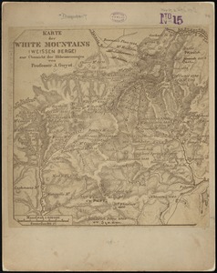
Karte der White Mountains (Weissen Berge) zur übersicht der höhenmessungen
9.
Leavitt's map with views of the White Mountains, New Hampshire : 1859
10.
Maine Central Railroad : through the White Mountains
11.
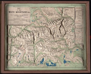
Map of the White Mountains, N.H : based on the best surveys
12.
Map of the White Mountains of New Hampshire from Walling's large map of the state, 1881
13.
Map of the White Mountains of New Hampshire from Walling's map of the state, 1877
14.
Map of the White Mountains of New Hampshire from Walling's map of the state 1877
15.
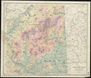
The National Publishing Company's topographic map of the White Mountains and central New Hampshire
16.
The White Mountains of New Hampshire
17.
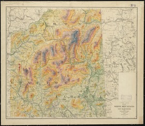
Geological map of the White Mountains, New Hampshire
18.
A Scott-Map of the White Mountains of New Hampshire
19.
The 100th anniversary map of Abraham Lincoln's visit to Massachusetts, September 11-23, 1848
20.
1630 shoreline
‹ Prev
Next ›
1
2
3
4
5
…
408
409


![Map showing the relative distances of Porsmouth [i.e. Portsmouth] and Boston from Concord & Manchester, N.H](https://bpldcassets.blob.core.windows.net/derivatives/images/commonwealth:7h14b104z/image_thumbnail_300.jpg)