Toggle navigation
LMEC Home
Exhibitions
Georeferencing
Tools for Teachers
Collections
My Favorites
Sign Up / Log In
Search
Search the map portal
Map Collection
Map Collection
Map Sets
Search
Search
Search for
Search In
All Fields
Creator
Title
Subject
Place
Search All Digital Collections
Advanced Search
301 Results
My Search
Start Over
More Like
commonwealth:7h149z66c
Remove constraint More Like: commonwealth:7h149z66c
Filter your Search
Place
North and Central America
234
United States
160
New York
31
Suffolk (county)
31
Boston
29
Canada
29
North America
27
Charleston (county)
10
more
Place
»
Topic
North America--Maps--Early works to 1800
18
Boston (Mass.)--History--Revolution, 1775-1783--Maps--Early works to 1800
16
Vues d'optique
10
Gibraltar--History--Siege, 1779-1783--Maps--Early works to 1800
9
New York (N.Y.)--Pictorial works--Early works to 1800
9
United States--History--French and Indian War, 1754-1763--Maps--Early works to 1800
9
United States--Maps--Early works to 1800
9
Boston (Mass.)--Pictorial works--Early works to 1800
8
more
Topic
»
Date
Date range begin
–
Date range end
Current results range from
1740
to
1853
View distribution
Creator
Faden, William, 1749-1836
33
Jefferys, Thomas, -1771
31
Le Rouge, Georges-Louis
23
Des Barres, Joseph F. W. (Joseph Frederick Wallet), 1722-1824
21
Sayer, Robert, 1725-1794
20
Korn, Christoph Heinrich, 1726-1783
11
Raspe, Gabriel Nicolaus, 1712-1785
11
Simcoe, John Graves, 1752-1806
10
more
Creator
»
Format
Maps/Atlases
257
Prints
32
Manuscripts
24
Drawings/Illustrations
9
Books
2
Documents
1
Georeferenced
Yes
13
No
288
Collection
American Revolutionary War-Era Maps
299
Richard H. Brown Revolutionary War Map Collection at Mount Vernon
293
Boston and New England Maps
7
Norman B. Leventhal Map Center Collection
4
Maritime Charts and Atlases
2
Urban Maps
2
American Antiquarian Society Collection
1
Library of Congress Collection
1
more
Collection
»
Available to use
Creative Commons license
294
No known restrictions
5
Search Constraints
Sort by date (desc)
relevance
title
date (asc)
date (desc)
Number of results to display per page
20 per page
10
per page
20
per page
50
per page
100
per page
View results as:
grid view
map view
Search Results
1.
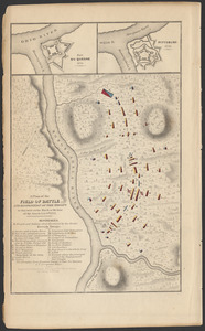
A plan of the field of battle and disposition of the troops as they were on the march at the time of the attack, July 9th, 1755
2.
[Chart of the Gulf Stream]
3.
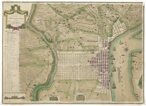
To the citizens of Philadelphia this plan of the city and its environs : is respectfully dedicated by the editors
4.
Vermont
5.
LʼAmérique Septentrionale et Méridionale divisée suivant ses différens pays
6.
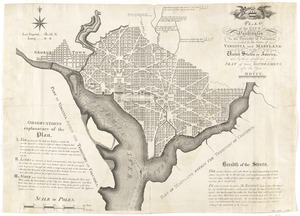
Plan of the city of Washington in the territory of Columbia, ceded by the states of Virginia and Maryland to the United States...
7.
L'Amerique divisée en ses principaux États
8.
Action at Spencer's ordinary : June 26th. 1781
9.
Affair at Quintin's Bridge : 18th March 1778
10.
Ambuscade of the Indians at Kingsbridge : August 31st. 1778
11.
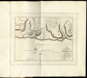
The landing at Burrell's, April 17th. 1781
12.
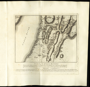
March of the Queens Rangers : Emmericks Corps, the Cavalry of the Legion under Lt. Col. Tarleton, and a detachment of the...
13.
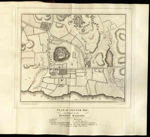
Plan of Oyster Bay, as fortified by the Queen's Rangers
14.
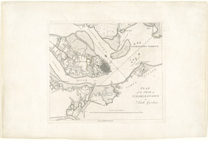
Plan of the siege of Charlestown in South Carolina
15.
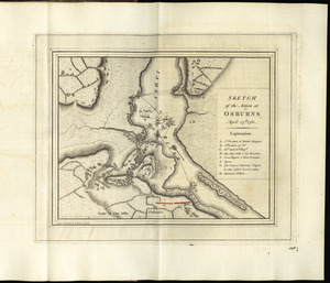
Sketch of the action at Osburns, April 27th. 1781
16.
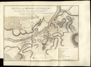
Sketch of the skirmish at Petersburg, between the Royal Army under the command of Major Genl. Phillips, and the American Army...
17.
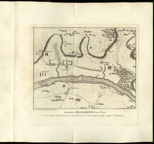
Skirmish at Richmond Jan. 5th. 1781
18.
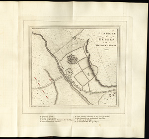
Surprize of rebels at Hancock's House
19.
Amérique Septentrionale dressée sur les relations les plus modernes des voyageurs et navigateurs, ou se remarquent les Etats...
20.
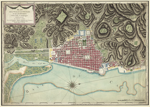
Plan de la ville du Cap Francois et de ses environs dans l'Isle St. Domingue
‹ Prev
Next ›
1
2
3
4
5
…
15
16
![[Chart of the Gulf Stream]](https://bpldcassets.blob.core.windows.net/derivatives/images/commonwealth:z603vr47j/image_thumbnail_300.jpg)