Toggle navigation
LMEC Home
Exhibitions
Georeferencing
Tools for Teachers
Collections
My Favorites
Sign Up / Log In
Search
Search the map portal
Map Collection
Map Collection
Map Sets
Search
Search
Search for
Search In
All Fields
Creator
Title
Subject
Place
Search All Digital Collections
Advanced Search
8163 Results
My Search
Start Over
More Like
commonwealth:6t053q72n
Remove constraint More Like: commonwealth:6t053q72n
Filter your Search
Place
North and Central America
4,911
United States
3,602
Suffolk (county)
1,026
Boston
999
Europe
963
Canada
427
France
269
Massachusetts
249
more
Place
»
Topic
Boston (Mass.)--Maps
574
United States--Maps
270
Real property--Massachusetts--Boston--Maps
174
Massachusetts--Maps
160
Landowners--Massachusetts--Boston--Maps
132
North America--Maps--Early works to 1800
103
New England--Maps
99
Europe--Maps
78
more
Topic
»
Date
Date range begin
–
Date range end
Current results range from
1482
to
2023
View distribution
Creator
United States. Hydrographic Office
357
O.H. Bailey & Co
148
Des Barres, Joseph F. W. (Joseph Frederick Wallet), 1722-1824
123
United States. Post Office Dept
120
Ptolemy, 2nd cent
100
Walling, Henry Francis, 1825-1888
94
Jefferys, Thomas, -1771
85
Geological Survey (U.S.)
82
more
Creator
»
Format
Maps/Atlases
8,104
Manuscripts
215
Prints
51
Books
36
Objects/Artifacts
10
Drawings/Illustrations
8
Posters
4
Georeferenced
Yes
869
No
7,294
Collection
Norman B. Leventhal Map Center Collection
8,162
Boston and New England Maps
2,184
Urban Maps
1,925
Maritime Charts and Atlases
750
American Revolutionary War-Era Maps
616
Boston Redevelopment Authority Collection
86
Richard H. Brown Revolutionary War Map Collection at Mount Vernon
1
Available to use
No known restrictions
8,021
Creative Commons license
47
Search Constraints
Sort by relevance
relevance
title
date (asc)
date (desc)
Number of results to display per page
20 per page
10
per page
20
per page
50
per page
100
per page
View results as:
grid view
map view
Search Results
1.
Supplement pour les Isles Antilles, extrait des carte Angloises
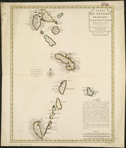
2.
Carte des Antilles françoises et des isles voisines
3.
Tabula novissima atque accuratissima Caraibicarum insularum sive Cannibalum : quae etiam Antillae Gallicae dicuntur, item...
4.
The Dutch islands of St. Eustatia, Saba, and St. Martins ; the French island of St. Bartholomew ; the English islands of St....
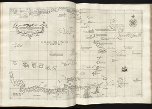
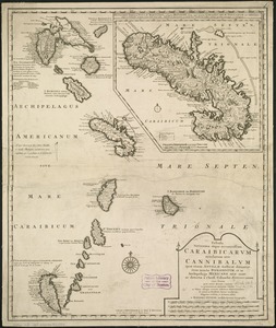
5.
[Alleen de Caribische Eilanden, vervat in 't groot]
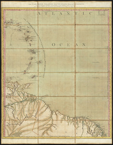
6.
The Caribbee Islands and Guayana
7.
Carta particolare dell'India Ocidentale, con la terra ferma dal' capo di Paria sin al' capo S. Romano
8.
A chart of the Caribe Islands
9.
A chart of the Caribe islands
10.
Les isles Antilles &c. entre lesquelles sont les Lucayes, et les Caribes
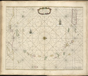
11.
Pascaert vande Caribes Eylanden
12.
The Caribbee Islands and Guayana
13.
The 100th anniversary map of Abraham Lincoln's visit to Massachusetts, September 11-23, 1848
14.
1630 shoreline
15.
1879. Progress map of the U.S. Geographical Surveys west of the 100th Meridian : prepared under the direction of 1st Lieut....
16.
1903 Map of Salem and surrounding places
17.
19th annual convention of the National Association of Real Estate Boards : at Tulsa, June 7 to June 11 in 1926
18.
2005 significant U.S. hurricane strikes
19.
The 2100 project : an atlas for the Green New Deal
20.
227 Harzgerode
‹ Prev
Next ›
1
2
3
4
5
…
408
409


![[Alleen de Caribische Eilanden, vervat in 't groot]](https://bpldcassets.blob.core.windows.net/derivatives/images/commonwealth:st74cw59p/image_thumbnail_300.jpg)