Toggle navigation
LMEC Home
Exhibitions
Georeferencing
Tools for Teachers
Collections
My Favorites
Sign Up / Log In
Search
Search the map portal
Map Collection
Map Collection
Map Sets
Search
Search
Search for
Search In
All Fields
Creator
Title
Subject
Place
Search All Digital Collections
Advanced Search
621 Results
My Search
Start Over
More Like
commonwealth:6q188644j
Remove constraint More Like: commonwealth:6q188644j
Filter your Search
Place
North and Central America
491
United States
249
North America
240
Canada
76
West Indies
60
New York
26
Asia
19
Pennsylvania
18
more
Place
»
Topic
North America--Maps--Early works to 1800
240
West Indies--Maps--Early works to 1800
63
United States--Maps--Early works to 1800
58
Canada--Maps--Early works to 1800
50
Great Britain--Colonies--America--Maps--Early works to 1800
22
Caribbean Area--Maps--Early works to 1800
17
Great Lakes Region (North America)--Maps--Early works to 1800
14
Northeastern States--Maps--Early works to 1800
12
more
Topic
»
Date
Date range begin
–
Date range end
Current results range from
1528
to
1999
View distribution
Creator
Jefferys, Thomas, -1771
32
Sayer, Robert, 1725-1794
23
Mitchell, John, 1711-1768
22
Gibson, J. (John), active 1750-1792
18
Anville, Jean Baptiste Bourguignon d', 1697-1782
17
Bellin, Jacques Nicolas, 1703-1772
17
Moll, Herman, d. 1732
15
Robert Sayer and John Bennett (Firm)
15
more
Creator
»
Format
Maps/Atlases
619
Manuscripts
8
Paintings
3
Ephemera
1
Objects/Artifacts
1
Prints
1
Georeferenced
Yes
14
No
607
Collection
American Revolutionary War-Era Maps
475
MacLean Collection Map Library
379
Norman B. Leventhal Map & Education Center Collection
166
New York Public Library Collection
34
Richard H. Brown Revolutionary War Map Collection at Mount Vernon
20
Maritime Charts and Atlases
12
Mapping Boston Collection
10
Sidney R. Knafel Map Collection at Phillips Academy
8
more
Collection
»
Available to use
No known restrictions
160
Creative Commons license
69
Search Constraints
Sort by relevance
relevance
title
date (asc)
date (desc)
Number of results to display per page
20 per page
10
per page
20
per page
50
per page
100
per page
View results as:
grid view
map view
Search Results
301.
Virginia et Nova Francia
302.
1.st sheet of De Witt's state-map of New-York
303.
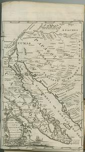
An accurate map of California drawn by the society of Jesuits, & dedicated to the king of Spain
304.
An accurate map of His Majesty's province of New Hampshire in New England, taken from actual surveys of all the inhabited part,...
305.
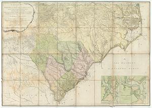
An accurate map of North and South Carolina with their Indian frontiers : shewing in a distinct manner all the mountains,...
306.
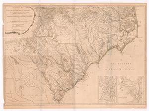
An accurate map of North and South Carolina with their Indian frontiers, shewing in a distinct manner all the mountains,...
307.
An accurate map of the commonwealth of Massachusetts exclusive of the district of Maine compiled pursuant to an act of the...
308.
An accurate map of the commonwealth of Massachusetts exclusive of the district of Maine compiled pursuant to an act of the...
309.
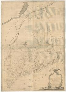
An accurate map, of the district of Maine being part of the commonwealth of Massachusetts : compiled pursuant to an act of the...
310.
An accurate map, of the district of Maine being part of the commonwealth of Massachusetts : compiled pursuant to an act of the...
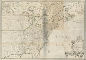
311.
America
312.
L'Amerique divisee en ses principales parties ou sont distingues les uns des autres les etats selon quils appartiennent...
313.
L'Amerique divisée en tous ses pays et etats
314.
L'Amerique divisee en tous ses pays et etats dressee sur de nouveaux memoires et sur les dernieres observations
315.
Amérique Méridionale
316.
Amérique Septentrionale
317.
Amerique Septentrionale avec les routes, distances en miles, villages et etablissements françois et anglois = North America
318.
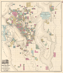
Anderson’s new guide map of the city of Seattle and environs
319.
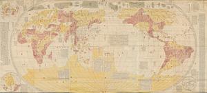
Bankoku yochi zu
320.
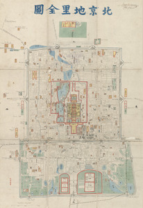
Beijing dili quantu
‹ Prev
Next ›
1
2
…
12
13
14
15
16
17
18
19
20
…
31
32