Toggle navigation
LMEC Home
Exhibitions
Georeferencing
Tools for Teachers
Collections
My Favorites
Sign Up / Log In
Search
Search the map portal
Map Collection
Map Collection
Map Sets
Search
Search
Search for
Search In
All Fields
Creator
Title
Subject
Place
Search All Digital Collections
Advanced Search
8162 Results
My Search
Start Over
More Like
commonwealth:4m90fn153
Remove constraint More Like: commonwealth:4m90fn153
Filter your Search
Place
North and Central America
4,912
United States
3,602
Suffolk (county)
1,026
Boston
999
Europe
962
Canada
427
France
269
Massachusetts
249
more
Place
»
Topic
Boston (Mass.)--Maps
574
United States--Maps
270
Real property--Massachusetts--Boston--Maps
174
Massachusetts--Maps
160
Landowners--Massachusetts--Boston--Maps
132
North America--Maps--Early works to 1800
103
New England--Maps
99
Europe--Maps
78
more
Topic
»
Date
Date range begin
–
Date range end
Current results range from
1482
to
2023
View distribution
Creator
United States. Hydrographic Office
357
O.H. Bailey & Co
148
Des Barres, Joseph F. W. (Joseph Frederick Wallet), 1722-1824
123
United States. Post Office Dept
120
Ptolemy, 2nd cent
100
Walling, Henry Francis, 1825-1888
94
Jefferys, Thomas, -1771
84
Geological Survey (U.S.)
82
more
Creator
»
Format
Maps/Atlases
8,103
Manuscripts
215
Prints
51
Books
36
Objects/Artifacts
10
Drawings/Illustrations
8
Posters
4
Georeferenced
Yes
868
No
7,294
Collection
Norman B. Leventhal Map Center Collection
8,162
Boston and New England Maps
2,184
Urban Maps
1,925
Maritime Charts and Atlases
750
American Revolutionary War-Era Maps
616
Boston Redevelopment Authority Collection
86
Available to use
No known restrictions
8,021
Creative Commons license
46
Search Constraints
Sort by relevance
relevance
title
date (asc)
date (desc)
Number of results to display per page
20 per page
10
per page
20
per page
50
per page
100
per page
View results as:
grid view
map view
Search Results
1.
Special-karte der Europäischen Türkey
2.
The Daily Telegraph war map no. 10
3.
The Daily telegraph war map no. 18
4.
The Daily Telegraph war map no. 19
5.
The Egyptian gazette war map no. 3
6.
Schedler's map of Turkey and Greece
7.
Türkei und Griechenland
8.
Carpathes - Roumanie - Balkans
9.
Rumänien und Bulgarien
10.
Dobroudja Campaigne, Oct. 1916 : Volhynie Campaigne, Oct. 1916 ; Izonzo Campaigne, Oct. 1916
11.
The Grecian archipelago, from the latest surveys
12.
Greece from the latest and best authorities
13.
Griechenland zur zeit des Peloponnesischen Krieges, nach den glaubwürdigsten geschichtsschreibern
14.
Das königreich Griechenland mit den Ionischen Inseln
15.
Königreich Griechenland nach den neuesten grenzbestimmungen
16.
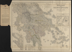
Das königreich Hellas oder Griechenland und die Ionischen Inseln (Ephtánisos)
17.
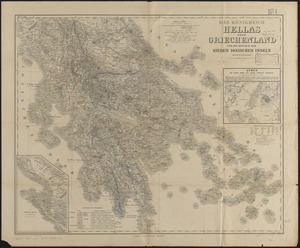
Das königreich Hellas oder Griechenland und die Republik der Sieben Ionischen Inseln (Ephtánisos)
18.
Rand, McNally & Co.'s new 14 x 21 map of Greece
19.
Tabulae maximae quibus illustrantur terrae veterum in usum scholarum
20.
Balkan Peninsula
‹ Prev
Next ›
1
2
3
4
5
…
408
409