Toggle navigation
LMEC Home
Exhibitions
Georeferencing
Tools for Teachers
Collections
My Favorites
Sign Up / Log In
Search
Search the map portal
Map Collection
Map Collection
Map Sets
Search
Search
Search for
Search In
All Fields
Creator
Title
Subject
Place
Search All Digital Collections
Advanced Search
8325 Results
My Search
Start Over
More Like
commonwealth:4m90fh92c
Remove constraint More Like: commonwealth:4m90fh92c
Filter your Search
Place
North and Central America
5,070
United States
3,684
Suffolk (county)
1,026
Boston
999
Europe
963
Canada
523
France
269
Massachusetts
250
more
Place
»
Topic
Boston (Mass.)--Maps
574
United States--Maps
272
Real property--Massachusetts--Boston--Maps
174
Massachusetts--Maps
161
United States--History--French and Indian War, 1754-1763--Maps
161
Landowners--Massachusetts--Boston--Maps
132
North America--Maps--Early works to 1800
103
New England--Maps
101
more
Topic
»
Date
Date range begin
–
Date range end
Current results range from
1482
to
2023
View distribution
Creator
United States. Hydrographic Office
357
O.H. Bailey & Co
148
Des Barres, Joseph F. W. (Joseph Frederick Wallet), 1722-1824
123
United States. Post Office Dept
120
Ptolemy, 2nd cent
100
Jefferys, Thomas, -1771
98
Walling, Henry Francis, 1825-1888
94
Geological Survey (U.S.)
82
more
Creator
»
Format
Maps/Atlases
8,265
Manuscripts
216
Prints
52
Books
36
Objects/Artifacts
10
Drawings/Illustrations
8
Posters
4
Georeferenced
Yes
869
No
7,456
Collection
Norman B. Leventhal Map Center Collection
8,162
Boston and New England Maps
2,184
Urban Maps
1,925
American Revolutionary War-Era Maps
779
Maritime Charts and Atlases
750
William L. Clements Library Collection
149
Boston Redevelopment Authority Collection
86
American Antiquarian Society Collection
9
more
Collection
»
Available to use
No known restrictions
8,022
Creative Commons license
50
Search Constraints
Sort by relevance
relevance
title
date (asc)
date (desc)
Number of results to display per page
20 per page
10
per page
20
per page
50
per page
100
per page
View results as:
grid view
map view
Search Results
1.
A Correct plan of the environs of Quebec, : and the battle fought on the 13th September, 1759: together with a particular...
2.
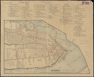
Plan of the city of Quebec : shewing the portions destroyed by the two great fires, May 28th & June 28th, 1845
3.
Quebec
4.
A plan of the disposition of the advanced party consisting of 400 men : to defend the workers in making the road
5.
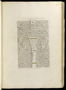
A plan of the encampment of the detachment from the little Meadows
6.
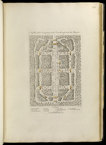
A plan of the line of march of the detachment from the little Meadows
7.
A plan of the line of march with the whole baggage
8.
A new map of the province of Quebec, : according to the Royal proclamation, of the 7th of October 1763
9.
A new map of the province of Quebec, : according to the Royal proclamation, of the 7th of October 1763
10.
Plan de la ville de Quebec
11.
Plan of the city of Quebec
12.
A Plan of the city of Quebec the capital of Canada. : As it surrendered 18 Septembr. 1759 to the British Fleet and Army,...
13.
An accurate map of Canada, with the adjacent countries; exhibiting the late seat of war between the English & French in those...
14.
Attaques des forts de Chouaguen en Amérique pris par les français commandés par le Marquis de Montcalm le 14 Août 1756
15.
Attaques des retranchemens devant le fort Carillon en Amérique par les anglais commandés par le général Abercrombie contre les...
16.
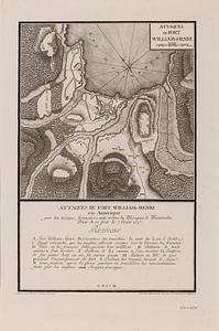
Attaques du fort William-Henri en Amérique par les troupes français aux ordres du Marquis de Montcalm prise de ce fort le 7...
17.
British attack upon Ticonderoga, July 7 & 8, 1758
18.
The Cedres
19.
Continuation of the Grande Riviere with the village of Fariole lying near Cape Torment on the north shore
20.
Continuation of the River Chaudière &c.
‹ Prev
Next ›
1
2
3
4
5
…
416
417