Toggle navigation
LMEC Home
Exhibitions
Georeferencing
Tools for Teachers
Collections
My Favorites
Sign Up / Log In
Search
Search the map portal
Map Collection
Map Collection
Map Sets
Search
Search
Search for
Search In
All Fields
Creator
Title
Subject
Place
Search All Digital Collections
Advanced Search
8163 Results
My Search
Start Over
More Like
commonwealth:4m90f684t
Remove constraint More Like: commonwealth:4m90f684t
Filter your Search
Place
North and Central America
4,912
United States
3,603
Suffolk (county)
1,026
Boston
999
Europe
963
Canada
427
France
269
Massachusetts
249
more
Place
»
Topic
Boston (Mass.)--Maps
574
United States--Maps
270
Real property--Massachusetts--Boston--Maps
174
Massachusetts--Maps
160
Landowners--Massachusetts--Boston--Maps
132
North America--Maps--Early works to 1800
103
New England--Maps
99
Europe--Maps
78
more
Topic
»
Date
Date range begin
–
Date range end
Current results range from
1482
to
2023
View distribution
Creator
United States. Hydrographic Office
357
O.H. Bailey & Co
148
Des Barres, Joseph F. W. (Joseph Frederick Wallet), 1722-1824
123
United States. Post Office Dept
120
Ptolemy, 2nd cent
100
Walling, Henry Francis, 1825-1888
94
Jefferys, Thomas, -1771
84
Geological Survey (U.S.)
82
more
Creator
»
Format
Maps/Atlases
8,104
Manuscripts
215
Prints
51
Books
36
Objects/Artifacts
10
Drawings/Illustrations
8
Posters
4
Georeferenced
Yes
869
No
7,294
Collection
Norman B. Leventhal Map Center Collection
8,163
Boston and New England Maps
2,184
Urban Maps
1,925
Maritime Charts and Atlases
750
American Revolutionary War-Era Maps
616
Boston Redevelopment Authority Collection
86
Applied Geographics, Inc. Records
1
Available to use
No known restrictions
8,022
Creative Commons license
46
Search Constraints
Sort by relevance
relevance
title
date (asc)
date (desc)
Number of results to display per page
20 per page
10
per page
20
per page
50
per page
100
per page
View results as:
grid view
map view
Search Results
1.
Texas and Pacific Rail Way
2.
Indian Territory, with part of the adjoining state of Kansas, &c
3.
Map of Oklahoma Territory
4.
Detail map of the Atlantic & Pacific Rail Road from the Mississippi River to the Pacific Ocean
5.
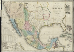
Mapa de los Estados Unidos de Méjico
6.
Spanish North America
7.
Colton's Texas
8.
Gallup's map of Texas
9.
Map of a tour from Independence to Santa Fé, Chihuahua, Monterey and Matamoros
10.
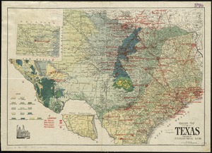
Map of Texas and parts of adjoining territories
11.
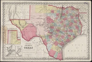
New map of the state of Texas
12.
Oil and gas fields of the state of Texas
13.
Post route map of the state of Texas showing post offices with the intermediate distances on mail routes in operation on the...
14.
Post route map of the state of Texas showing post offices with the intermediate distances on mail routes in operation on the...
15.
Post route map of the state of Texas with adjacent parts of Louisiana, Arkansas, Indian Territory and of the Republic of Mexico...
16.
Texas New Yorker travelers' railroad map of the State of Texas
17.
Texas New Yorker's railroad map of Texas : showing all completed and proposed routes, with principal rivers, county boundaries...
18.
Topographical map of the province of lower Texas on the Gulf of Mexico
19.
Mexico - US border infrastructure
20.
The 100th anniversary map of Abraham Lincoln's visit to Massachusetts, September 11-23, 1848
‹ Prev
Next ›
1
2
3
4
5
…
408
409