Toggle navigation
LMEC Home
Exhibitions
Georeferencing
Tools for Teachers
Collections
My Favorites
Sign Up / Log In
Search
Search the map portal
Map Collection
Map Collection
Map Sets
Search
Search
Search for
Search In
All Fields
Creator
Title
Subject
Place
Search All Digital Collections
Advanced Search
8174 Results
My Search
Start Over
More Like
commonwealth:3f462w91d
Remove constraint More Like: commonwealth:3f462w91d
Filter your Search
Place
North and Central America
4,923
United States
3,606
Suffolk (county)
1,026
Boston
999
Europe
963
Canada
427
France
269
Massachusetts
249
more
Place
»
Topic
Boston (Mass.)--Maps
574
United States--Maps
270
Real property--Massachusetts--Boston--Maps
174
Massachusetts--Maps
160
Landowners--Massachusetts--Boston--Maps
132
North America--Maps--Early works to 1800
103
New England--Maps
99
Europe--Maps
78
more
Topic
»
Date
Date range begin
–
Date range end
Current results range from
1482
to
2023
View distribution
Creator
United States. Hydrographic Office
357
O.H. Bailey & Co
148
Des Barres, Joseph F. W. (Joseph Frederick Wallet), 1722-1824
123
United States. Post Office Dept
120
Ptolemy, 2nd cent
100
Walling, Henry Francis, 1825-1888
94
Jefferys, Thomas, -1771
84
Geological Survey (U.S.)
82
more
Creator
»
Format
Maps/Atlases
8,115
Manuscripts
218
Prints
51
Books
36
Objects/Artifacts
10
Drawings/Illustrations
8
Posters
4
Georeferenced
Yes
869
No
7,305
Collection
Norman B. Leventhal Map Center Collection
8,162
Boston and New England Maps
2,183
Urban Maps
1,925
Maritime Charts and Atlases
750
American Revolutionary War-Era Maps
627
Boston Redevelopment Authority Collection
86
Richard H. Brown Revolutionary War Map Collection at Mount Vernon
6
Harvard Map Collection
2
more
Collection
»
Available to use
No known restrictions
8,023
Creative Commons license
55
Search Constraints
Sort by relevance
relevance
title
date (asc)
date (desc)
Number of results to display per page
20 per page
10
per page
20
per page
50
per page
100
per page
View results as:
grid view
map view
Search Results
1.
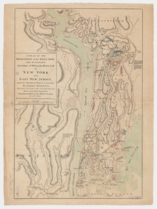
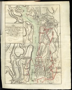
A plan of the operations of the King's army under the command of General Sr. William Howe, K.B. in New York and east New Jersey...
2.
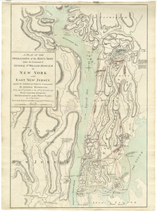
A plan of the operations of the King's army : under the command of General Sr. William Howe, K.B. in New York and east New...
3.
A plan of the operations of the King's army under the command of General Sr. William Howe, K.B. in New York and east New...
4.
A plan of the operations of the King's army under the command of General Sr. William Howe, K.B. in New York and east New Jersey...
5.
Plan von den operationen der Koeniglichen Armee unter dem General Sir William Howe : in Neuyorck und Ost-Neujerseÿ gegen die...
6.
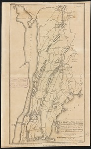
A plan of the country from Frogspoint to Croton River shewing the positions of the American and British armies from the 12th of...
7.
A New and accurate map of the present seat of war in North America, comprehending New Jersey, Philadelphia, Pensylvania,...
8.
A new and accurate map of the province of New York and part of the Jerseys, New England and Canada, shewing the scenes of our...
9.
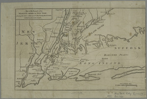
A plan of New York Island, with part of Long Island, Staten Island & east New Jersey, with a particular description of the...
10.
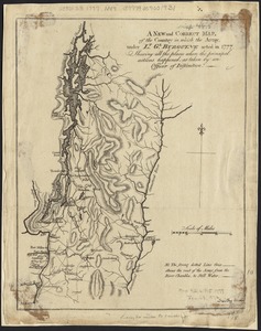
A new and correct map, of the country in which the Army, under Lt. Gl. Burgoyne acted in 1777, shewing all the places where the...
11.
Chart and plan of the harbour of New York & the couny. adjacent, from Sandy Hook to Kingsbridge, comprehending the whole of New...
12.
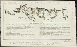
Plan de la bataille de Montmouth où le Gl. Washington commandait l'Armée Américaine et le Gl. Clinton l'Armée Anglaise, le...
13.
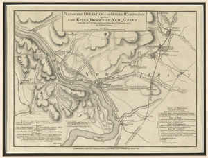
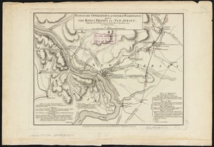
Plan of the operations of General Washington, against the Kings troops in New Jersey : from the 26th. of December 1776, to the...
14.
A plan of New York Island, and part of Long Island, with the circumjacent country, as far as Dobbs's Ferry to the north, and...
15.
A map of the country in which the army under Lt. General Burgoyne acted in the campaign of 1777 : shewing the marches of the...
16.
Map of the progress of His Majesty's armies in New York, during the late campaign : illustrating the accounts published in the...
17.
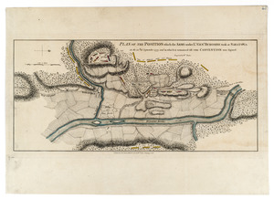
[Plan of the battles of Saratoga]
18.
Plan of the position which the army under Lt. Genl. Burgoine took at Saratoga on the 10th of September, 1777, and in which it...
19.
Chart and plan of the harbour of New York & the couny. adjacent, from Sandy Hook to Kingsbridge, comprehending the whole of New...
20.
Plan of the operations of General Washington, against the Kings troops in New Jersey : from the 26th. of December 1776, to the...
‹ Prev
Next ›
1
2
3
4
5
…
408
409


![[Plan of the battles of Saratoga]](https://bpldcassets.blob.core.windows.net/derivatives/images/commonwealth:z603vw07d/image_thumbnail_300.jpg)