Toggle navigation
LMEC Home
Exhibitions
Georeferencing
Tools for Teachers
Collections
My Favorites
Sign Up / Log In
Search
Search the map portal
Map Collection
Map Collection
Map Sets
Search
Search
Search for
Search In
All Fields
Creator
Title
Subject
Place
Search All Digital Collections
Advanced Search
8720 Results
My Search
Start Over
More Like
commonwealth:2514p1541
Remove constraint More Like: commonwealth:2514p1541
Filter your Search
Place
North and Central America
5,927
United States
4,844
Massachusetts
2,079
Europe
1,396
Suffolk (county)
1,046
Boston
1,019
Canada
449
Asia
439
more
Place
»
Topic
Boston (Mass.)--Maps
586
United States--Maps
282
Real property--Massachusetts--Boston--Maps
175
Massachusetts--Maps
162
Landowners--Massachusetts--Boston--Maps
133
North America--Maps--Early works to 1800
104
New England--Maps
102
Europe--Maps
79
more
Topic
»
Date
Date range begin
–
Date range end
Current results range from
1482
to
2023
View distribution
Creator
United States. Hydrographic Office
595
O.H. Bailey & Co
148
Des Barres, Joseph F. W. (Joseph Frederick Wallet), 1722-1824
123
United States. Post Office Dept
120
Ptolemy, 2nd cent
100
Walling, Henry Francis, 1825-1888
94
Geological Survey (U.S.)
86
Jefferys, Thomas, -1771
86
more
Creator
»
Format
Maps/Atlases
8,660
Manuscripts
215
Prints
56
Books
36
Objects/Artifacts
10
Drawings/Illustrations
8
Posters
5
Georeferenced
Yes
869
No
7,851
Collection
Norman B. Leventhal Map & Education Center Collection
8,697
Boston and New England Maps
2,233
Urban Maps
2,023
Maritime Charts and Atlases
1,083
American Revolutionary War-Era Maps
629
Boston Redevelopment Authority Collection
87
Sidney R. Knafel Map Collection at Phillips Academy
10
MacLean Collection Map Library
6
more
Collection
»
Available to use
No known restrictions
8,552
Creative Commons license
57
Search Constraints
Sort by relevance
relevance
title
date (asc)
date (desc)
Number of results to display per page
20 per page
10
per page
20
per page
50
per page
100
per page
View results as:
grid view
map view
Search Results
4941.
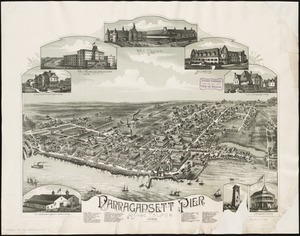
Narragansett Pier, Rhode Island : 1888
4942.
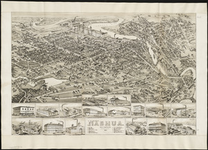
Nashua, New Hampshire
4943.
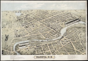
Nashua, N.H : 1875
4944.
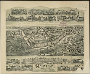
Natick, Rhode Island
4945.
A nation of immigrants
4946.
National forests
4947.
National forests, state forests, national parks, national monuments and Indian reservations
4948.
National Forests with related projects and data
4949.
National Geographic Magazine map of China and its territories
4950.
The National Geographic Magazine map of Mexico
4951.
The National Geographic magazine map of the countries bordering the Mediterranean Sea
4952.
The National Geographic magazine map of the new Balkan states and Central Europe
4953.
National Highways map of the state of Massachusetts showing one thousand miles of national highways proposed by the National...
4954.
National highways map of the United States showing one hundred fifty thousand miles of national highways proposed by the...
4955.
National highways map of the United States showing one hundred thousand miles of national highways proposed by the National...
4956.
National highways map of the United States showing principal transcontinental highways and connecting system of one hundred...
4957.
National map of New England states Vermont, New Hampshire, Massachusetts, Connecticut, Rhode Island and Maine showing counties...
4958.
National map of the United States
4959.
The National Publishing Company's 1900 census map of Maine : showing all counties, towns, railroads, cities, villages, post...
4960.
The National Publishing Company's new railroad, post-office and county map of Illinois : with complete index of all...
‹ Prev
Next ›
1
2
…
244
245
246
247
248
249
250
251
252
…
435
436