Toggle navigation
LMEC Home
Exhibitions
Georeferencing
Tools for Teachers
Collections
My Favorites
Sign Up / Log In
Search
Search the map portal
Map Collection
Map Collection
Map Sets
Search
Search
Search for
Search In
All Fields
Creator
Title
Subject
Place
Search All Digital Collections
Advanced Search
8194 Results
My Search
Start Over
More Like
commonwealth:1257bb08n
Remove constraint More Like: commonwealth:1257bb08n
Filter your Search
Place
North and Central America
4,943
United States
3,633
Suffolk (county)
1,046
Boston
1,019
Europe
963
Canada
427
France
269
Massachusetts
249
more
Place
»
Topic
Boston (Mass.)--Maps
574
United States--Maps
270
Real property--Massachusetts--Boston--Maps
174
Massachusetts--Maps
160
Landowners--Massachusetts--Boston--Maps
132
North America--Maps--Early works to 1800
103
New England--Maps
99
Europe--Maps
78
more
Topic
»
Date
Date range begin
–
Date range end
Current results range from
1482
to
2023
View distribution
Creator
United States. Hydrographic Office
357
O.H. Bailey & Co
148
Des Barres, Joseph F. W. (Joseph Frederick Wallet), 1722-1824
125
United States. Post Office Dept
120
Ptolemy, 2nd cent
100
Walling, Henry Francis, 1825-1888
94
Jefferys, Thomas, -1771
84
Geological Survey (U.S.)
82
more
Creator
»
Format
Maps/Atlases
8,135
Manuscripts
215
Prints
51
Books
36
Objects/Artifacts
10
Drawings/Illustrations
8
Posters
4
Georeferenced
Yes
873
No
7,321
Collection
Norman B. Leventhal Map Center Collection
8,179
Boston and New England Maps
2,199
Urban Maps
1,930
Maritime Charts and Atlases
757
American Revolutionary War-Era Maps
641
Boston Redevelopment Authority Collection
86
Mapping Boston Collection
17
Richard H. Brown Revolutionary War Map Collection at Mount Vernon
6
more
Collection
»
Available to use
No known restrictions
8,022
Creative Commons license
77
Search Constraints
Sort by relevance
relevance
title
date (asc)
date (desc)
Number of results to display per page
50 per page
10
per page
20
per page
50
per page
100
per page
View results as:
grid view
map view
Search Results
1.
Boston, its environs and harbour, with the rebel works raised against that town in 1775 : from the observations of Lieut. Page...
2.
Bowles's map of the seat of war in New England, comprehending the provinces of Massachusets Bay, and New Hampshire : with the...
3.
Carte de la ville, baye et environs de Baston
4.
Carte des environs de Boston, capitale de la Nlle. Angleterre en Amerique
5.
A chart of the harbour of Boston
6.
A chart of the harbour of Boston
7.
A chart of the harbour of Boston
8.
A map of the most inhabited part of New England : containing the provinces of Massachusets Bay and New Hampshire, with the...
9.
A map of the most inhabited part of New England : containing the provinces of Massachusets Bay and New Hampshire, with the...
10.
A new and accurate plan of the town of Boston in New England : A new plan of Boston Harbor from an actual survey
11.
Plan de la ville de Boston et ses environs
12.
The seat of war in New England, by an American volunteer : with the marches of the several corps sent by the Colonies towards...
13.
Hafen von Boston
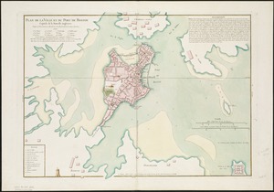
14.
Plan de la ville et du port de Boston : capitale de la Nouvelle Angleterre : erigée prémierement en 1630, et en 1735 elle fut...
15.
A plan of the town and chart of the harbour of Boston exhibiting a view of the islands, castle forts, and entrances into the...
16.
The seat of war, in New England, by an American volunteer : with the marches of the several corps sent by the colonies, towards...
17.
The seat of war in New England, by an American volunteer : with the marches of the several corps sent by the Colonies towards...
18.
Boston with its environs
19.
Carta rappresentante il porto di Boston
20.
Carte du port et havre de Boston avec les côtes adjacentes, dans laquel on a tracée les camps et les retranchemens occupé,...
21.
A chart of the Harbour of Boston, with the soundings, sailing-marks, and other directions
22.
A map of the most inhabited part of New England : containing the provinces of Massachusets Bay and New Hampshire, with the...
23.
Boston
24.
A chart of the coast of New England, from Beverly to Scituate harbour, including the ports of Boston and Salem
25.
Die gegend um Boston
26.
Grundriss von der stadt Boston und ihren gegenden
27.
A map of 100 miles round Boston
28.
A new plan of ye great town of Boston in New England in America, with the many additionall buildings & new streets to the year...
29.
A new plan of ye great town of Boston in New England in America, with the many additionall [sic] buildings, & new streets, to...
30.
Particular draughts and plans of some of the principal towns and harbours belonging to the English, French, and Spaniards, in...
31.
Plan de Boston
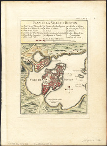
32.
Plan de la ville de Boston
33.
Plan de la ville de Boston
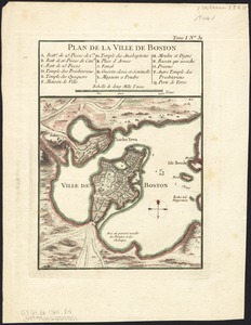
34.
Plan de la ville et du port de Boston : capitale de la Nouvelle Angleterre
35.
A plan of Boston, from actual survey
36.
A plan of Boston, from actual survey
37.
Thirty-miles round Boston
38.
The town of Boston in New England
39.
The town of Boston in New England
40.
The town of Boston in New England
41.
Baye et port de Boston
42.
Baye et port de Boston
43.
Boston et ses environs
44.
Boston Harbour in New England
45.
Boston, with its environs
46.
Carte du port et havre de Boston avec les côtes adjacentes, dans laquel on a tracée les camps et les retranchemens occupé,...
47.
Carte du port et havre de Boston avec les côtes adjacentes, dans laquel on a tracée les camps et les retranchemens occupé,...
48.
Carte particuliere du havre de Boston : avec les sondes les bancs de Sable, les rochers les Amaies et les autres directions...
49.
Carte particuliere du havre de Boston : avec les sondes les bancs de Sable, les rochers les Amaies et les autres directions...
50.
A chart of the harbour of Boston
‹ Prev
Next ›
1
2
3
4
5
…
163
164


![A new plan of ye great town of Boston in New England in America, with the many additionall [sic] buildings, & new streets, to the year, 1769](https://bpldcassets.blob.core.windows.net/derivatives/images/commonwealth:3f462v50z/image_thumbnail_300.jpg)