Toggle navigation
LMEC Home
Exhibitions
Georeferencing
Tools for Teachers
Collections
My Favorites
Sign Up / Log In
Search
Search the map portal
Map Collection
Map Collection
Map Sets
Search
Search
Search for
Search In
All Fields
Creator
Title
Subject
Place
Search All Digital Collections
Advanced Search
8298 Results
My Search
Start Over
More Like
commonwealth:0r96fq62v
Remove constraint More Like: commonwealth:0r96fq62v
Filter your Search
Place
North and Central America
5,024
United States
3,667
Suffolk (county)
1,029
Boston
1,002
Europe
964
Canada
440
France
270
Massachusetts
249
more
Place
»
Topic
Boston (Mass.)--Maps
574
United States--Maps
270
Real property--Massachusetts--Boston--Maps
174
Massachusetts--Maps
160
Manuscript maps--Early works to 1800
138
Landowners--Massachusetts--Boston--Maps
132
North America--Maps--Early works to 1800
105
New England--Maps
99
more
Topic
»
Date
Date range begin
–
Date range end
Current results range from
1482
to
2023
View distribution
Creator
United States. Hydrographic Office
357
O.H. Bailey & Co
148
Des Barres, Joseph F. W. (Joseph Frederick Wallet), 1722-1824
123
United States. Post Office Dept
120
Ptolemy, 2nd cent
100
Walling, Henry Francis, 1825-1888
94
Jefferys, Thomas, -1771
84
Geological Survey (U.S.)
82
more
Creator
»
Format
Maps/Atlases
8,239
Manuscripts
350
Prints
51
Books
36
Objects/Artifacts
10
Drawings/Illustrations
8
Posters
4
Georeferenced
Yes
871
No
7,427
Collection
Norman B. Leventhal Map Center Collection
8,162
Boston and New England Maps
2,185
Urban Maps
1,931
Maritime Charts and Atlases
767
American Revolutionary War-Era Maps
747
Library of Congress Collection
97
Boston Redevelopment Authority Collection
86
Newberry Library Collection
39
Available to use
No known restrictions
8,021
Creative Commons license
143
Search Constraints
Sort by relevance
relevance
title
date (asc)
date (desc)
Number of results to display per page
20 per page
10
per page
20
per page
50
per page
100
per page
View results as:
grid view
map view
Search Results
1.
Manuscript survey of a property in Kittery, Maine
2.
The world with all modern discoveries
3.
1. Prise de Newport par d'Estaing, 1778 : 2. Embossage de Ternay à Newport, 1780
4.
20 tracts, Charleston
5.
Amerique Septentrionale : Acadie ou Nouvelle Ecosse aux anglois : Annapolis Royal
6.
Armstrong County
7.
Barbadoes
8.
Boston & harbour
9.
Boston Harbor, Massachusetts
10.
[Boston Harbour, with the surroundings, &c]
11.
Boston, its environs and harbour : with the rebels works raised against that town in 1775
12.
Boston, S. West part : No. 25
13.
Campement de l'armée à Tombecbe
14.
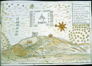
[Campement] de l'armée franc̦oise [devant u]n village des ennemis, les Chicachas le 26 [de mais] 1736
15.
Cantonment of His Majesty's forces in N. America : according to the disposition now made & to be compleated as soon as...
16.
Cantonment of the forces in North America 11th. Octr. 1765
17.
Carta esférica de la canal entre Puerto Rico y Santo Domingo
18.
Carta esférica de la Ysla de la Granada
19.
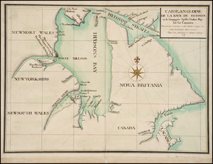
Carte angloise de la Baye de Hudson ou la compagnie apellee Hudson Bay fait son commerce : tirée de la liasse des concecions...
20.
Carte de la coste de la Louisiane, depuis la Baye de St. Bernard jusqu'a celle de Saint Joseph : ou tous les ports, rades, et...
‹ Prev
Next ›
1
2
3
4
5
…
414
415


![[Boston Harbour, with the surroundings, &c]](https://bpldcassets.blob.core.windows.net/derivatives/images/commonwealth:t722hs94d/image_thumbnail_300.jpg)


![[Campement] de l'armée franc̦oise [devant u]n village des ennemis, les Chicachas le 26 [de mais] 1736](https://bpldcassets.blob.core.windows.net/derivatives/images/commonwealth:z603vn65v/image_thumbnail_300.jpg)