Toggle navigation
LMEC Home
Exhibitions
Georeferencing
Tools for Teachers
Collections
My Favorites
Sign Up / Log In
Search
Search the map portal
Map Collection
Map Collection
Map Sets
Search
Search
Search for
Search In
All Fields
Creator
Title
Subject
Place
Search All Digital Collections
Advanced Search
13385 Results
Filter your Search
Place
North and Central America
9,353
United States
7,078
Suffolk (county)
1,664
Boston
1,621
Europe
1,035
Canada
949
Massachusetts
794
New York
532
more
Place
»
Topic
Boston (Mass.)--Maps
741
City planning--Massachusetts--Boston--Maps
418
United States--History--Revolution, 1775-1783--Maps
329
United States--Maps
315
Urban renewal--Massachusetts--Boston--Maps
254
Real property--Massachusetts--Boston--Maps
252
Massachusetts--Maps
219
Insurance surveys
197
more
Topic
»
Date
Date range begin
–
Date range end
Current results range from
1482
to
2023
View distribution
Creator
United States. Hydrographic Office
595
Boston Redevelopment Authority
403
Des Barres, Joseph F. W. (Joseph Frederick Wallet), 1722-1824
247
Royal United Services Institute for Defence and Security Studies
160
Jefferys, Thomas, -1771
154
George, III, King of Great Britain, 1738-1820
152
George, IV, King of Great Britain, 1762-1830
151
O.H. Bailey & Co
148
more
Creator
»
Format
Maps/Atlases
13,205
Manuscripts
985
Prints
102
Books
49
Drawings/Illustrations
44
Photographs
15
Objects/Artifacts
13
Documents
7
more
Format
»
Georeferenced
Yes
979
No
12,406
Collection
Norman B. Leventhal Map Center Collection
8,891
American Revolutionary War-Era Maps
3,305
Boston and New England Maps
2,804
Urban Maps
2,397
Maritime Charts and Atlases
1,150
William L. Clements Library Collection
910
Library of Congress Collection
618
Boston Redevelopment Authority Collection
475
more
Collection
»
Available to use
No known restrictions
9,952
Creative Commons license
1,677
Search Constraints
Sort by relevance
relevance
title
date (asc)
date (desc)
Number of results to display per page
20 per page
10
per page
20
per page
50
per page
100
per page
View results as:
grid view
map view
Search Results
1321.
Bressia = vulgo Bresse
1322.
La Bretagne : divisée en ses neuf eveschés qui font aussi l'estendue des receptes de la generalité de Nantes
1323.
Breton Sound
1324.
Bridge from Staten Island to the Jersies, by Cn. Laird's description
1325.
Bridgewater, Massachusetts : 1887
1326.
Bridgton, Maine : U.S.A., 1888
1327.
Brighton and Allston urban design strategy
1328.
Brighton park : Brighton district
1329.
Bristol, Conn : looking north-east
1330.
Bristol, Grafton County, N.H. 1884
1331.
Bristol, Vt
1332.
Britannia Ducatus = Duché de Bretaigne
1333.
Britannia prout divisa suit temporibus Anglo-Saxonum praesertim durante illorum heptarchia
1334.
Britannicae Insulae in quibus Albion seu Britannia Major, et Ivernia seu Britannia Minor : juxta Ptolemaei mentem divisae, tùm...
1335.
British America, comprehending Canada, Labrador, New-Foundland, Nova Scotia &c
1336.
The British and Russian frontiers in Central Asia
1337.
British attack upon Ticonderoga, July 7 & 8, 1758
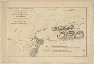
1338.
British camp at Trudruffrin from [sic] : with the attack made by Major General Grey against the rebels near White Horse Tavern
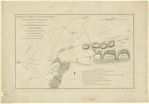
1339.
British camp at Trudruffrin from the 18th. to the 21st. of September 1777 : with the attack made by Major General Grey against...
1340.
British camp at Trudruffrin from the 18th. to the 21st. of September 1777 : with the attack made by Major General Grey against...
‹ Prev
Next ›
1
2
…
63
64
65
66
67
68
69
70
71
…
669
670


![British camp at Trudruffrin from [sic]](https://bpldcassets.blob.core.windows.net/derivatives/images/commonwealth:q524nb58k/image_thumbnail_300.jpg)