Search Constraints
Search Results


![[Chart of Tierra del Fuego and the Strait of Magellan]](https://bpldcassets.blob.core.windows.net/derivatives/images/commonwealth:w9505s59b/image_thumbnail_300.jpg)


2232. Chatham, Mass
![Chatham Mfg. Co., Mill No. 2, Winston-Salem, N.C. [insurance map]](https://bpldcassets.blob.core.windows.net/derivatives/images/commonwealth:2r36vc786/image_thumbnail_300.jpg)


2235. Chester

2236. Chester, Mass : 1885

![[Chiapas]](https://bpldcassets.blob.core.windows.net/derivatives/images/commonwealth:4m90fj278/image_thumbnail_300.jpg)
2238. [Chiapas]
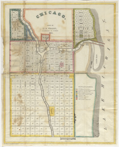
2239. Chicago
2240. Chicago

2241. Chicago

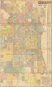
2242. Chicago


![Chicopee Mfg. Corp. (Cotton Mill), Chicopee Falls, Mass. [insurance map]](https://bpldcassets.blob.core.windows.net/derivatives/images/commonwealth:2r36vc433/image_thumbnail_300.jpg)

2248. Chicopee River
![[Chignecto Bay and vicinity]](https://bpldcassets.blob.core.windows.net/derivatives/images/commonwealth:z603vj91v/image_thumbnail_300.jpg)
![[Chignecto Bay and vicinity]](https://bpldcassets.blob.core.windows.net/derivatives/images/commonwealth:z603vj878/image_thumbnail_300.jpg)
![[Chignecto Bay and vicinity]](https://bpldcassets.blob.core.windows.net/derivatives/images/commonwealth:z603vj89t/image_thumbnail_300.jpg)
![[Chignecto Bay and vicinity]](https://bpldcassets.blob.core.windows.net/derivatives/images/commonwealth:z603vj85q/image_thumbnail_300.jpg)
![[Chignecto Bay and vicinity]](https://bpldcassets.blob.core.windows.net/derivatives/images/commonwealth:9g54xk66m/image_thumbnail_300.jpg)

2254. Chikyū bankoku hōzu

2255. Le Chili

2256. Chili

2257. Chili

2258. Chili


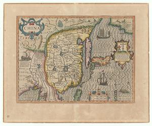
2260. China

2261. China

2262. China

2263. China

2264. China
2265. China


2269. China


2274. China, military regions


2276. China Sea


![[Chippewa] National Forest, Minnesota](https://bpldcassets.blob.core.windows.net/derivatives/images/commonwealth:th83pg40d/image_thumbnail_300.jpg)


2291. Chūseki keishi chizu