Toggle navigation
LMEC Home
Exhibitions
Georeferencing
Tools for Teachers
Collections
My Favorites
Sign Up / Log In
Search
Search the map portal
Map Collection
Map Collection
Map Sets
Search
Search
Search for
Search In
All Fields
Creator
Title
Subject
Place
Search All Digital Collections
Advanced Search
35 Results
My Search
Start Over
Greenland
Remove constraint Greenland
Filter your Search
Place
North and Central America
20
Greenland
14
Canada
13
North America
10
Arctic
5
Atlantic Ocean
4
Mesoamerica
4
South America
4
more
Place
»
Topic
Greenland--Maps--Early works to 1800
7
Greenland--Maps
6
America--Maps--Early works to 1800
4
North America--Maps
4
Arctic regions--Maps
3
Coasts--Greenland--Maps--Early works to 1800
3
Western Hemisphere--Maps--Early works to 1800
3
America--Discovery and Exploration--Maps--Early works to 1800
2
more
Topic
»
Date
Date range begin
–
Date range end
Current results range from
1507
to
1904
View distribution
Creator
United States. Hydrographic Office
5
Green, John, -1757
3
Jefferys, Thomas, -1771
3
Sayer, Robert, 1725-1794
3
Anville, Jean Baptiste Bourguignon d', 1697-1782
2
Colom, Jacob Aertsz, 1599-1673
2
Merian, Matthaeus, 1593-1650
2
Boas, F. Dr.
1
more
Creator
»
Format
Maps/Atlases
35
Objects/Artifacts
1
Georeferenced
Yes
2
No
33
Collection
Norman B. Leventhal Map Center Collection
27
American Revolutionary War-Era Maps
7
Maritime Charts and Atlases
5
American Antiquarian Society Collection
2
Richard H. Brown Revolutionary War Map Collection at Mount Vernon
2
Mapping Boston Collection
1
New York Public Library Collection
1
Pechter Family Map Collection at Phillips Academy
1
more
Collection
»
Available to use
No known restrictions
27
Creative Commons license
4
Search Constraints
Sort by relevance
relevance
title
date (asc)
date (desc)
Number of results to display per page
20 per page
10
per page
20
per page
50
per page
100
per page
View results as:
grid view
map view
Search Results
1.
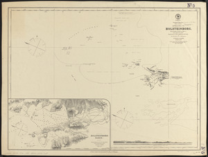
Greenland, west coast, Davis Strait, approaches to Holsteinborg : from British surveys of 1853-4, with additions to 1875
2.
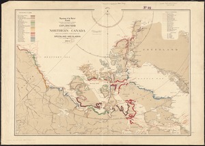
Explorations in northern Canada and adjacent portions of Greenland and Alaska, 1904
3.
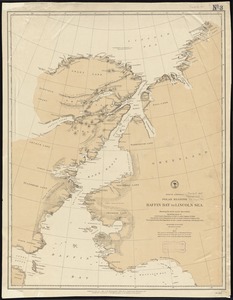
Chart comprizing Greenland with the countries and islands about Baffin's and Hudson's Bays
4.
Chart comprizing Greenland with the countries and islands about Baffin's and Hudson's Bays
5.
The Arctic Ocean between Greenland and Nova Zemla and between the 60th and 82d parallels of latitude : from the Swedish,...
6.
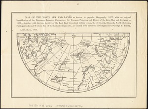
Map of the North Sea and lands as known in popular geography, 1877, with an original identification of the Frisland, Islanda,...
7.
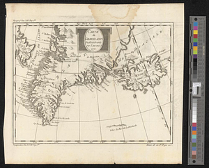
Carte du Groenland dressée et gravée
8.
Scandinavia
9.
Dominion of Canada
10.
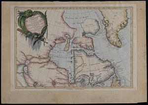
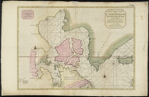
Partie de l'Amerique septentrionale : qui comprend le Canada, la Louisiane, le Labrador, le Groenland, La Nouvelle Angleterre,...
11.
Arctic America : eastern sheet
12.
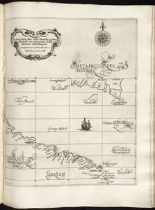
Carta particolare della Meta Incognita Australe con una parte della America Settentrionale
13.
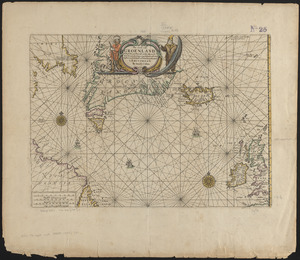
Pas caerte van Groenland, Ysland, Straet Davids en Ian Mayen eyland hoemen de selvige van Hitland en de noort kusten van...
14.
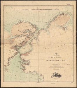
North America, polar regions, Baffin Bay to Lincoln Sea : showing the recent discoveries by civil engineer R.E. Peary, U.S.N.,...
15.
Carte particuliere de l'Amerique septentrionale ou sont compris le Destroit de Davids, le Destroit de Hudson, &c
16.
North America polar regions : Baffin Bay to Lincoln Sea, showing the most recent discoveries including those of U.S.S. Polaris...
17.
De Noordelyckste Zee Kusten van America van Groenland door de Straet Davis ende Straet Hudson tot Terra Neuf =...
18.
Paskaert van de Noordelijckste kuste van America van Groenland door de Straet Davis en de Straet Hudson tot Terra Neuf
19.
A chart of North and South America, including the Atlantic and Pacific Oceans, with the nearest coasts of Europe, Africa and Asia
20.
An accurate map of North America
‹ Prev
Next ›
1
2