Toggle navigation
LMEC Home
Exhibitions
Georeferencing
Tools for Teachers
Collections
My Favorites
Sign Up / Log In
Search
Search the map portal
Map Collection
Map Collection
Map Sets
Search
Search
Search for
Search In
All Fields
Creator
Title
Subject
Place
Search All Digital Collections
Advanced Search
26 Results
My Search
Start Over
Barbados
Remove constraint Barbados
Filter your Search
Place
Barbados
17
North and Central America
6
Antigua and Barbuda
4
Jamaica
4
Antigua
3
North America
3
West Indies
3
Bolívar
2
more
Place
»
Topic
Barbados--Maps--Early works to 1800
12
Jamaica--Maps--Early works to 1800
4
Antigua--Maps--Early works to 1800
3
Barbados--Maps
3
North America--Maps--Early works to 1800
3
West Indies--Maps--Early works to 1800
3
Barbados--Defences--Maps, Manuscript--Early works to 1800
2
Barbados--History--1775-1783--Maps, Manuscript--Early works to 1800
2
more
Topic
»
Date
Date range begin
–
Date range end
Current results range from
1660
to
1879
View distribution
Creator
Bellin, Jacques Nicolas, 1703-1772
2
George, III, King of Great Britain, 1738-1820
2
George, IV, King of Great Britain, 1762-1830
2
Jefferys, Thomas, -1771
2
Jefferys, Thomas, d. 1771
2
Le Rouge, Georges-Louis
2
Lea, Philip, fl. 1683-1700
2
Walker, Thomas
2
more
Creator
»
Format
Maps/Atlases
26
Manuscripts
3
Georeferenced
Yes
3
No
23
Collection
Norman B. Leventhal Map Center Collection
17
American Revolutionary War-Era Maps
14
Richard H. Brown Revolutionary War Map Collection at Mount Vernon
3
British Library Collection
2
Sidney R. Knafel Map Collection at Phillips Academy
2
Maritime Charts and Atlases
1
Newberry Library Collection
1
Urban Maps
1
more
Collection
»
Available to use
No known restrictions
17
Creative Commons license
5
Search Constraints
Sort by relevance
relevance
title
date (asc)
date (desc)
Number of results to display per page
20 per page
10
per page
20
per page
50
per page
100
per page
View results as:
grid view
map view
Search Results
1.
Barbados
2.
Barbadoes
3.
Barbadoes
4.
The island of Barbadoes : divided into its parishes, with the roads, paths, &c. according to an actual and accurate survey
5.
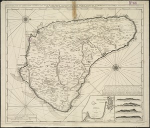
A topographical map of the island of Barbados : based upon Mayo's original survey in 1721 and corrected to the year 1846
6.
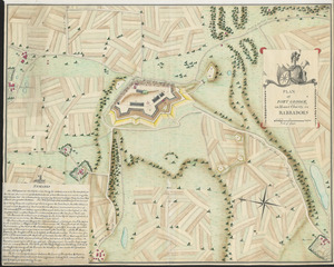
PLAN of FORT GEORGE, on Mount Charity, in BARBADOES
7.
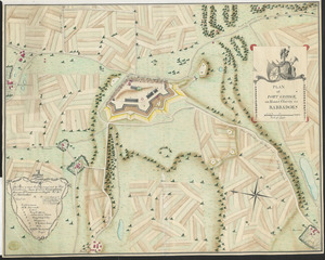
PLAN of FORT GEORGE, on Mount Charity, in BARBADOES
8.
Pascaerte van Brazil en Nieu Nederlandt, van Corvo en Flores tot de Barbados
9.
A topographicall description and admeasurement of the yland of Barbados in the West Indyaes : with the mrs. names of the...
10.
Nieuwe land en zeekaart van het eyland Barbados geleegen in West India onder de Caribesse Eylanden : afgeteekent na de nieuste...
11.
The principall islands in America belonging to the English empire viz Iamaica, Barbados, Antegoa, St. Christophers & Bermudos
12.
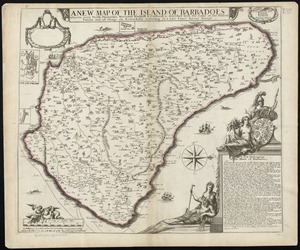
A new map of the Island of Barbadoes wherein every parish, plantation, watermill, windmill & cattlemill, is described with the...
13.
Dominia anglorum in præcipuis insulis Americæ ut sunt insula : S. Christophori, Antegoa, Iamaica, Barbados : nec non insulae...
14.
The English pilot. The fourth book. Describing the West-India navigation, from Hudson's-Bay to the River Amazones. Particulary...
15.
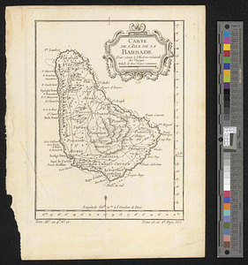
Carte de l'isle de la Barbade pour servir à l'histoire générale des voyages
16.
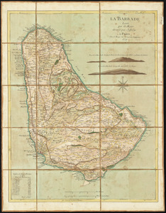
La Barbade
17.
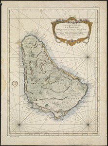
Carte de l'Isle de La Barbade : avec une description geographique de cette isle
18.
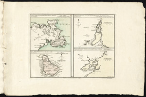
Port, baye cul de sac Royal dans la Martinique -- Isle des Barbades une des Isles Antilles -- Cartagene située sur le Côte de...
19.
Plans des isles, rades, et ports de plusieurs lieux de l'Amérique : tirés de la Carte angloise de Mr. Popple publiée en 1733...
20.
Antigue : levée par Robert Baker, Arpenteur General de l'Isle ; traduit de l'Anglais
‹ Prev
Next ›
1
2