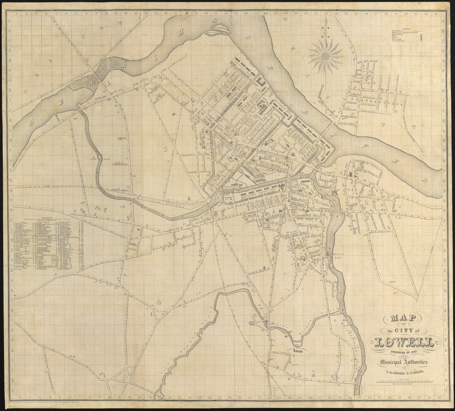
Map of the city of Lowell : surveyed in 1841 by order of the principal authorities
Item Information
- Title:
- Map of the city of Lowell : surveyed in 1841 by order of the principal authorities
- Description:
-
America Transformed: By the early 1840s, when this map was prepared, Lowell had grown to a population of more than 20,000, making it the state’s second largest city. The map details the footprint and function of individual buildings and demonstrates how dominant the textile industry was in the community. The map notes ten named textile mills as well as an additional 19 mills and factories. Mills were located near the river and canals, which provided waterpower for the factories. The directory lists company boarding houses, agents and superintendent houses, as well as numerous churches, schools, and other public buildings.
- Cartographer:
- Beard, Ithamar A., 1789-1871
- Cartographer:
- Hoar, J.
- Engraver:
- Boynton, George W., -1884
- Name on Item:
-
by I.A. Beard & J. Hoar ; engraved by G.W. Boynton
- Date:
-
(c) 1842
- Format:
-
Maps/Atlases
- Location:
- Private Collection
- Collection (local):
-
Private Collection
- Subjects:
-
Lowell (Mass.)--Maps
Industries--Massachusetts--Lowell--Maps
Buildings--Masssachusetts--Lowell--Maps
- Places:
-
MassachusettsMiddlesex (county)Lowell
- Extent:
- 1 map ; 74 x 83 cm
- Terms of Use:
-
No known copyright restrictions.
No known restrictions on use.
- Publisher:
-
[Massachusetts] :
I.A. Beard
- Scale:
-
Scale approximately 1:4,500
- Language:
-
English
- Notes:
-
Shows wards, businesses and buildings.
Includes references to buildings.
"Entered according to Act of Congress in the year 1842 by I.A. Beard in the Clerks Office of the District Court of Massachusetts.
- Notes (exhibitions):
-
Exhibited: "America transformed. Part 1: the United States expands westward," organized by the Norman B. Leventhal Map & Education Center at the Boston Public Library, 2019.
- Identifier:
-
06_01_016720