Toggle navigation
LMEC Home
Exhibitions
Georeferencing
Tools for Teachers
Collections
My Favorites
Sign Up / Log In
Search
Search the map portal
Map Collection
Map Collection
Map Sets
Search
Search
Search for
Search In
All Fields
Creator
Title
Subject
Place
Search All Digital Collections
Advanced Search
16 Results
My Search
Start Over
1974
Remove constraint 1974
Filter your Search
Place
North and Central America
14
United States
14
Boston
6
Suffolk (county)
6
Canada
2
Massachusetts
2
New England
2
Atlantic Ocean
1
more
Place
»
Topic
Boston (Mass.)--Maps
4
City planning--Massachusetts--Boston--Maps
4
Land use--Massachusetts--Boston--Maps
3
Buildings--Massachusetts--Boston--Maps
2
Faneuil Hall (Boston, Mass.)
2
Lindbergh, Charles A. (Charles Augustus), 1902-1974
2
Massachusetts Bay Transportation Authority
2
United States--Maps
2
more
Topic
»
Date
Date range begin
–
Date range end
Current results range from
1711
to
1990
View distribution
Creator
Boston Redevelopment Authority
5
Downtown Waterfront Corporation
2
Weaver, David Judkins, 1951-
2
Associated American Artists
1
Bogar, James C.
1
Cities, inc.
1
Clegg, Ernest
1
Connecticut. Natural Resources Center
1
more
Creator
»
Format
Maps/Atlases
16
Manuscripts
2
Georeferenced
No
16
Collection
Boston and New England Maps
8
Norman B. Leventhal Map Center Collection
8
Boston Redevelopment Authority Collection
5
Urban Maps
5
David Judkins Weaver Papers
3
American Revolutionary War-Era Maps
2
British Library Collection
1
Maritime Charts and Atlases
1
more
Collection
»
Available to use
No known restrictions
14
Creative Commons license
1
Search Constraints
Sort by date (desc)
relevance
title
date (asc)
date (desc)
Number of results to display per page
20 per page
10
per page
20
per page
50
per page
100
per page
View results as:
grid view
map view
Search Results
1.
Open space map of Connecticut, lands dedicated as open space, and selected undeveloped land, lands managed but not dedicated as...
2.
Charlestown urban renewal area project no. Mass. R-55 Boston - Suffolk County - Massachusetts delivery parcel plan : parcel...
3.
Boston public schools and police reporting areas
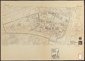
4.
South Cove urban renewal area R-92 : disposition plan
5.
Downtown waterfront-Faneuil Hall project urban renewal area Massachusetts R-77 : illustrative site plan
6.
Downtown waterfront-Faneuil Hall project urban renewal area Massachusetts R-77 : illustrative site plan
7.
Black in New England 1840
8.
Cape Cod
9.
Metropolitan Boston transportation map : subway, bus, rail
10.
Paul Sample's America, its soil
11.
Map in commemoration of the travels of Charles A. Lindbergh
12.
Map showing the overland and overseas flights of Charles A. Lindbergh
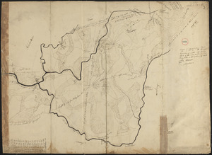
13.
Plan of Palmer made by William Woods, dated 1830
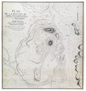
14.
Plan de la position de l'armée sous les ordre de son Excellence le Lieutenant General Bourgoyne à Saratoga etant sur la...
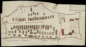
15.
Plan du Fort du Sault de St. Louis et du village des sauvages Iroquois
16.
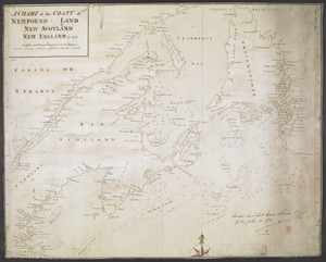
A CHART of the COAST OF NEWFOUND-LAND NEW SCOTLAND NEW ENGLAND &c. 1711