Toggle navigation
LMEC Home
Exhibitions
Georeferencing
Tools for Teachers
Collections
My Favorites
Sign Up / Log In
Search
Search the map portal
Map Collection
Map Collection
Map Sets
Search
Search
Search for
Search In
All Fields
Creator
Title
Subject
Place
Search All Digital Collections
Advanced Search
187 Results
My Search
Start Over
1900
Remove constraint 1900
Filter your Search
Place
North and Central America
146
United States
116
Massachusetts
48
Boston
26
Suffolk (county)
26
Asia
18
Cuba
13
Europe
13
more
Place
»
Topic
Boston (Mass.)--Maps
13
United States--Maps
10
Franco-Prussian War, 1870-1871--Aerial views
7
France--History--1789-1900--Aerial views
6
Germany--History--1789-1900--Aerial views
6
Havana (Cuba)--Maps
6
Luzon (Philippines)--Maps
6
New England--Maps--Early works to 1800--Facsimiles
5
more
Topic
»
Date
Date range begin
–
Date range end
Current results range from
1764
to
2005
View distribution
Creator
United States. War Department
16
United States. Congress (56th, 2nd session : 1900-1901). Senate
10
United States. Congress. Senate. Committee on Foreign Relations
10
United States. Army. Department of Cuba
9
United States. Congress (56th, 2nd session : 1900-1901). House
8
United States. Government Printing Office
8
United States. Army. Corps of Engineers
7
Geo. H. Walker & Co.
6
more
Creator
»
Format
Maps/Atlases
182
Manuscripts
7
Photographs
3
Prints
2
Books
1
Drawings/Illustrations
1
Posters
1
Georeferenced
Yes
21
No
166
Collection
Norman B. Leventhal Map & Education Center Collection
176
Boston and New England Maps
17
Urban Maps
16
Robert E. Diefenbach Map Collection at Phillips Academy
5
American Revolutionary War-Era Maps
3
Massachusetts Real Estate Atlases
3
Maritime Charts and Atlases
2
Colonial and Revolutionary Boston
1
more
Collection
»
Available to use
No known restrictions
176
Creative Commons license
2
Search Constraints
Sort by relevance
relevance
title
date (asc)
date (desc)
Number of results to display per page
20 per page
10
per page
20
per page
50
per page
100
per page
View results as:
grid view
map view
Search Results
81.
Metropolitan Manila
82.
The National Publishing Company's new railroad, post-office and county map of Washington and Oregon : with complete index of...
83.
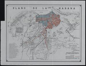
Plano de la Habana : showing track laying completed and paved
84.
Plano de la Habana : showing status of survey for street grades
85.
City of Boston Granary Burying Ground : Boston proper
86.
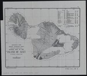
General map of the island of Maui : as surveyed to March 1st 1880
87.
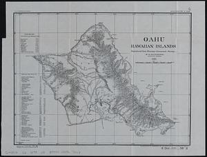
Oahu, Hawaiian Islands
88.
Plano de la Habana : showing proposed paving for the city of Havana as encluded in specifications recently drawn up
89.
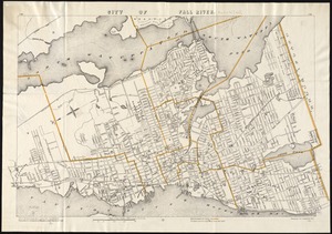
City of Fall River
90.
Map of Bohemia, Pensacola Bay, Florida
91.
Outline map of Puerto Rico
92.
Mobile Bay, Alabama
93.
Map of Choctaw Nation, Indian Territory
94.
Proposed site for navy yard, Port Orchard, Puget Sound, Washington Ter.
95.
Puget Sound, Washington Territory
96.
Coast chart no. 186 : Choctawhatchee Inlet to Pensacola Entrance, West Florida : report of Navy Yard Site Commission, Gulf of...
97.
Karte der Philippinen : in zwei sectionen : nördliches und südliches blatt
98.
Map of north eastern China
99.
Map of Texas and parts of adjoining territories
100.
The National Publishing Company's new railroad, post-office and county map of Illinois : with complete index of all...
‹ Prev
Next ›
1
2
3
4
5
6
7
8
9
10