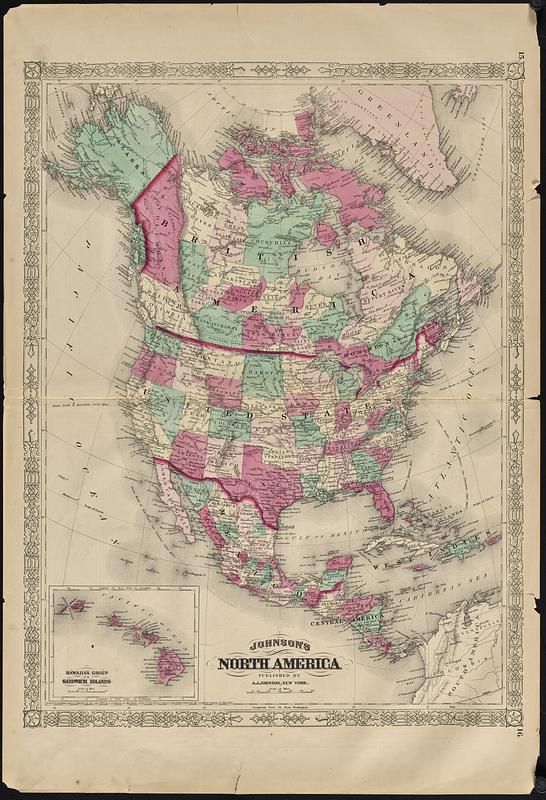
Johnson's North America

Item Information
- Title:
- Johnson's North America
- Cartographer:
- Johnson, A. J. (Alvin Jewett), 1827-1884
- Name on Item:
-
A.J. Johnson
- Date:
-
[1869]
- Format:
-
Maps/Atlases
- Location:
-
Boston Public Library
Norman B. Leventhal Map & Education Center - Collection (local):
-
Norman B. Leventhal Map & Education Center Collection
- Subjects:
-
North America--Maps
- Places:
-
North America (area)
- Extent:
- 1 map : color ; 57 x 42 cm
- Terms of Use:
-
No known copyright restrictions.
No known restrictions on use.
- Publisher:
-
New York :
A.J. Johnson
- Scale:
-
Scale approximately 1:15,000,000
- Language:
-
English
- Notes:
-
In "Johnson's new illustrated family atlas of the world," plate 15-16 (New York : A.J. Johnson, 1869).
Relief shown by hachures.
Prime meridians: Greenwich and Washington.
Inset: Hawaiian group or Sandwich Islands.
Text and illustrations on verso, pages 9-10.
- Notes (date):
-
This date is inferred.
- Identifier:
-
06_01_018843A
06_01_018843B
- Call #:
-
G1019 .J5 1869
- Barcode:
-
39999085969390


