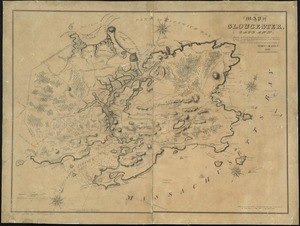
Ipswich and Annisquam harbors, Massachusetts [archaeology in 1874]
![Ipswich and Annisquam harbors, Massachusetts [archaeology in 1874]](https://bpldcassets.blob.core.windows.net/derivatives/images/commonwealth:2f75vg12c/image_access_800.jpg)
Item Information
- Title:
- Ipswich and Annisquam harbors, Massachusetts [archaeology in 1874]
- Cartographer:
- LeBaron, John Francis, 1865-1935
- Contributor:
- Bache, A. D. (Alexander Dallas), 1806-1867
- Surveyor:
- Boutelle, C. O. (Charles Otis)
- Surveyor:
- Whiting, Henry L.
- Surveyor:
- Woodhull, M. (Maxwell)
- Surveyor:
- Trenchard, Stephen Decatur
- Surveyor:
- Rodgers, C. R. P. (Christopher Raymond Perry), 1819-1892
- Draftsman:
- Key, John Ross, 1832-1920
- Draftsman:
- Shoepf, A.
- Engraver:
- Metzeroth, G. B.
- Engraver:
- Maedel, A. (Adolph)
- Engraver:
- Petersen, A.
- Publisher:
- United States Coast Survey
- Name on Item:
-
by J. Francis LeBaron ; from a trigonometrical survey under the direction of A.D. Bache Superintendent of the Coast of the United States ; triangulation by C.O. Boutelle Assist. ; topography by H.L. Whiting Assist. ; hydrography by the parties under the command of Lieuts. M. Woodhull, S.D. Trenchard & C.R.P. Rodgers U.S.N. Assists.
- Date:
-
[1874]
- Format:
-
Maps/Atlases
- Genre:
-
Nautical charts
Manuscript maps
- Location:
-
Boston Public Library
Norman B. Leventhal Map & Education Center - Collection (local):
-
Norman B. Leventhal Map & Education Center Collection
- Subjects:
-
Ipswich Bay (Mass.)--Maps
Ipswich (Mass.)--Maps
Annisquam (Gloucester, Mass.)--Maps
Algonquian Indians--Massachusetts--Ipswich--Antiquities--Maps
Algonquian Indians--Massachusetts--Gloucester--Antiquities--Maps
Navigation--Massachusetts--Ipswich Bay
Navigation--Massachusetts--Ipswich
Navigation--Massachusetts--Gloucester
Harbors--Massachusetts--Ipswich--Maps
Harbors--Massachusetts--Gloucester--Maps
- Places:
-
MassachusettsEssex (county)Ipswich Bay
MassachusettsEssex (county)Annisquam Harbor (bay)
- Extent:
- 1 map : hand colored ; 47 x 72 cm
- Terms of Use:
-
No known copyright restrictions.
No known restrictions on use.
- Place of origin:
-
[Boston]
- Scale:
-
Scale 1:20,000
- Language:
-
English
- Notes:
-
Manuscript in ink below title: Archaeology in 1874 by [stamped] J. Francis LeBaron, Civil and Railroad Engineer, 32 Pemberton Square, Boston.
Possibly a draft or notes for LeBaron's Archaelogical map of Castle Neck and vicinity, published 1874.
Relief shown by hachures. Depths shown by gradient tints and soundings.
"Red'd dr'ng by J.R. Key & A. Shoepf ; eng'd by G.B. Metzeroth, A. Maedel, & A. Petersen."
Includes sailing directions, note, currents, light houses, beacons, and tides.
"Electrotype copy no. 5 by G. Mathiot U.S.C.S."
- Notes (date):
-
This date is inferred.
- Identifier:
-
06_01_018638
- Call #:
-
G3764.I6E15 1874 .L43
- Barcode:
-
39999085969481