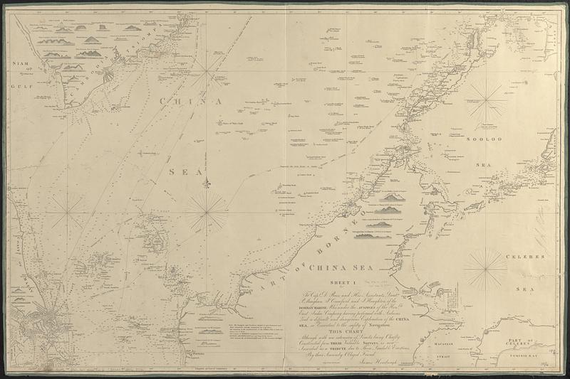
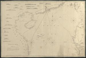
China Sea

Item Information
- Title:
- China Sea
- Cartographer:
- Horsburgh, James
- Engraver:
- Bateman, J. (John)
- Contributor:
- East India Company
- Name on Item:
-
James Horsburgh ; engraved by John Bateman
- Date:
-
1850
- Format:
-
Maps/Atlases
- Genre:
-
Nautical charts
- Location:
-
Boston Public Library
Norman B. Leventhal Map & Education Center - Collection (local):
-
Norman B. Leventhal Map & Education Center Collection
- Subjects:
-
South China Sea--Maps
Pacific Coast (Asia)--Maps
Nautical charts--South China Sea
- Places:
-
South China Sea
- Extent:
- 1 map on 2 sheets : mounted on linen ; 127 x 99 cm, on sheets 68 x 101 cm
- Terms of Use:
-
No known copyright restrictions.
No known restrictions on use.
- Publisher:
-
[London] :
James Horsburgh
- Scale:
-
Scale approximately 1:2,250,000
- Language:
-
English
- Table of Contents:
-
Sheet I. [Southern section]
Sheet II. [Northern section]
- Notes:
-
Shows several "best routes" for shipping.
Relief shown by hachures. Depths shown by soundings.
"To Capt. D. Ross, and his assistants Lieuts. P. Maughan, P. Crawford, and J. Houghton, of the Bombaymarine; who under the auspices of the Honble. East India Company having performed with arduous zeal a difficult and dangerous exploration of the China Sea, so essential to the safety of navigation, this chart although with an extension of limits, being chiefly constructed from their valuable surveys, is now inscribed as a tribute due to those laudable exertions, by their sincerely obliged friend. James Horsburgh."--Sheet I.
"Published by James Horsburgh, Hydrographer to the Honble. East India Company, October 1st 1821--according to Act of Parliament, with additions to 1846."--Lower margin of sheet I.
"Published 1st Feby. 1823, by James Horsburgh, Hydrographer to the Honble. E.I. Co., according to Act of Parliament. Additions to 1850"--Lower left corner of sheet II.
Includes notes and 43 views of coastlines as seen from the ocean.
- Identifier:
-
06_01_017636B
06_01_017636A
- Call #:
-
G9237.S6P5 1850 .H67
- Barcode:
-
39999085960795