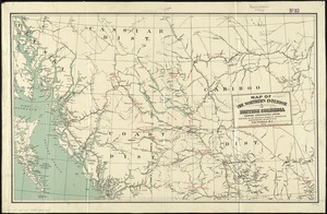
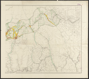
Southern British Columbia : map showing disposition of lands


Item Information
- Title:
- Southern British Columbia : map showing disposition of lands
- Cartographer:
- Canada. Department of the Interior
- Contributor:
- Lynch, F. C. C. (Francis Christopher Chisholm), 1884-
- Name on Item:
-
prepared under the direction of F.C.C. Lynch, Superintendent of Railway Lands, Canada Department of the Interior
- Date:
-
1914
- Format:
-
Maps/Atlases
- Location:
-
Boston Public Library
Norman B. Leventhal Map & Education Center - Collection (local):
-
Norman B. Leventhal Map & Education Center Collection
- Subjects:
-
Land use--British Columbia--Maps
Real property--British Columbia--Maps
British Columbia--Maps
- Places:
-
CanadaProvince of British Columbia (province)
- Extent:
- 1 map on 2 sheets : color ; 64 x 134 cm, on sheets 76 x 86 cm and 76 x 72 cm
- Terms of Use:
-
No known copyright restrictions.
No known restrictions on use.
- Publisher:
-
[Ottawa] :
The Dept.
- Edition:
- 4th ed. corr. to Jan. 1914
- Scale:
-
Scale 1:500,000. 7.89 miles to one inch
- Language:
-
English
- Notes:
-
Shows land ownership.
Relief shown by spot heights.
Includes list of elevations.
Inset: [Victoria, Vancouver and surrounding area].
- Identifier:
-
06_01_011622A
06_01_011622B
- Call #:
-
G3511.G4 1914 .C36
- Barcode:
-
39999065687814