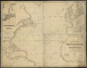
North Atlantic track chart
Item Information
- Title:
- North Atlantic track chart
- Cartographer:
- U.S. Coast and Geodetic Survey
- Lithographer:
- Julius Bien & Co.
- Date:
-
1884
- Format:
-
Maps/Atlases
- Location:
-
Boston Public Library
Norman B. Leventhal Map & Education Center - Collection (local):
-
Norman B. Leventhal Map & Education Center Collection
- Subjects:
-
Magnetic declination--North Atlantic Ocean--Maps
North Atlantic Ocean--Maps
- Places:
-
Atlantic Ocean
- Extent:
- 1 map : color ; 22 x 78 cm
- Terms of Use:
-
No known copyright restrictions.
No known restrictions on use.
- Publisher:
-
[Washington, D.C.] :
U.S. Coast & Geodetic Survey
- Scale:
-
Scale 1:8,000,000
- Projection:
- conic projection
- Language:
-
English
- Notes:
-
April 1884.
"No. 3029."
- Identifier:
-
06_01_015440
- Call #:
-
G9110 1884 .U82
- Barcode:
-
39999085937157
![Wind and current chart of the North Atlantic [sheet 1]](https://bpldcassets.blob.core.windows.net/derivatives/images/commonwealth:jh344151t/image_thumbnail_300.jpg)