German military maneuvers near Stettin from September 3 to September 14, 1900


Item Information
- Title:
- German military maneuvers near Stettin from September 3 to September 14, 1900
- Publisher:
- Prussia (Germany). Landesaufnahme
- Date:
-
[1900]
- Format:
-
Maps/Atlases
- Location:
-
Boston Public Library
Norman B. Leventhal Map Center - Collection (local):
-
Norman B. Leventhal Map Center Collection
- Subjects:
-
Military maneuvers
Szczecin (Poland)--Maps
Województwo Zachodniopomorskie (Poland)--Maps
Germany. Heer
- Places:
-
PolandSzczecin
PolandWest Pomeranian Voivodeship (voivodeship)
- Extent:
- 6 maps : color ; 65 x 73 cm
- Terms of Use:
-
No known copyright restrictions.
No known restrictions on use.
- Publisher:
-
[Place of publication not identified] :
[publisher not identified]
- Scale:
-
Scale 1:100,000
- Language:
-
German
English
- Table of Contents:
-
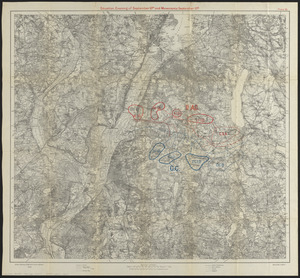
Plate II. Situation. Evening of September 8th and movements September 10th
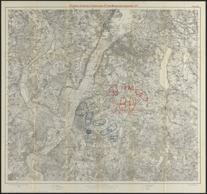
Plate III. Situation. Evening of September 10th and movements September 11th
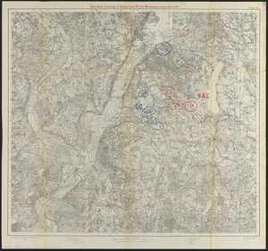
Plate IV. Situation. Evening of September 11th and movements September 12th
Situation. Evening of September 12th and movements September 13th
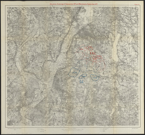
Plate VI. Situation. Evening of September 13th and movements September 14th
- Notes:
-
Maps showing a practice military maneuver by the German Imperial Army.
Relief shown by hachures and spot heights. Depths shown by soundings and isolines.
Base map: Karte des Deutschen Reiches 1:100,000, Stettin sheet.
Military maneuver described in "Notes of military interest for 1900" / War Department, Adjutant General's Office, (Washington : Govt. Print. Off., 1901), pages 197-231.
Map in German. Title at head of map in English.
Boston Public Library copy imperfect: Lacking plate I.
- Notes (date):
-
This date is inferred.
- Identifier:
-
06_01_016315
06_01_016316
06_01_016317
06_01_016319
06_01_016318
- Call #:
-
G6524.S93R3 1900 .G4
- Barcode:
-
39999085945218


