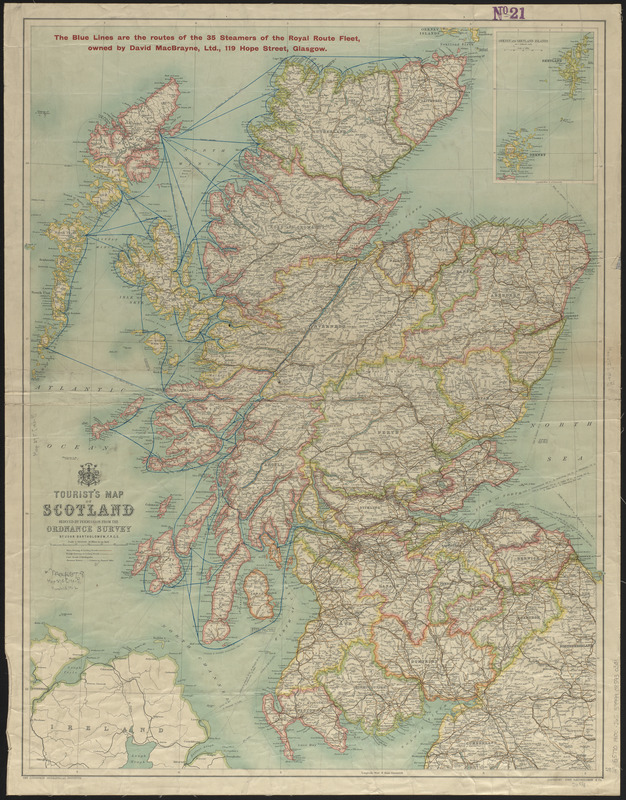
Tourist's map of Scotland : reduced by permission from the Ordnance Survey by John Bartholomew, F.R.G.S.
Item Information
- Title:
- Tourist's map of Scotland : reduced by permission from the Ordnance Survey by John Bartholomew, F.R.G.S.
- Cartographer:
- John Bartholomew & Co.
- Publisher:
- Edinburgh Geographical Institute
- Date:
-
[1900–1909]
- Format:
-
Maps/Atlases
- Location:
-
Boston Public Library
Norman B. Leventhal Map & Education Center - Collection (local):
-
Norman B. Leventhal Map & Education Center Collection
- Subjects:
-
Steamboat lines--Scotland--Maps
Scotland--Maps
- Places:
-
Scotland
- Extent:
- 1 map : color ; 72 x 57 cm
- Terms of Use:
-
No known copyright restrictions.
No known restrictions on use.
- Publisher:
-
[Edinburgh] :
John Bartholomew & Co.
- Scale:
-
Scale 1:633,600
- Language:
-
English
- Notes:
-
Relief shown by hachures and spot heights.
Shows driving, cycling, and cart roads, bridlepaths, and steamer routes.
In red at top of map: The blue lines are the routes of the 35 steamers of the Royal Route Fleet, owned by David MacBrayne, Ltd., 119 Hope Street, Glasgow.
Inset: Orkney and Shetland islands.
- Notes (date):
-
This date is inferred.
- Identifier:
-
06_01_015044
- Call #:
-
G5770 1900 .J65
- Barcode:
-
39999085930301