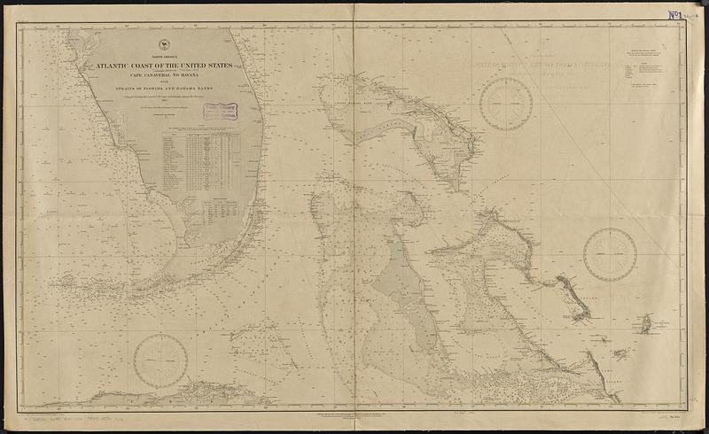
North America, Atlantic coast of the United States, Cape Canaveral to Havana with Straits of Florida and Bahama Banks : compiled from the latest U.S. coast and British Admiralty surveys 1886
Item Information
- Title:
- North America, Atlantic coast of the United States, Cape Canaveral to Havana with Straits of Florida and Bahama Banks : compiled from the latest U.S. coast and British Admiralty surveys 1886
- Issuing body:
- United States. Hydrographic Office
- Draftsman:
- Bolles, C. P. (Charles P.)
- Engraver:
- Evans, H. C. (Henry C.)
- Engraver:
- Waddey, J. A. (John A.)
- Name on Item:
-
drawn by C.P. Bolles ; engraved by H.C. Evans and J.A. Waddey
- Date:
-
[1889]
- Format:
-
Maps/Atlases
- Genre:
-
Nautical charts
- Location:
-
Boston Public Library
Norman B. Leventhal Map & Education Center - Collection (local):
-
Norman B. Leventhal Map & Education Center Collection
- Subjects:
-
Atlantic Coast (Fla.)--Maps
Florida, Straits of--Maps
Great Bahama Bank (Bahamas)--Maps
Little Bahama Bank (Bahamas)--Maps
Coasts--Florida--Maps
Nautical charts--Florida, Straits of
Nautical charts--Bahamas--Great Bahama Bank
Nautical charts--Bahamas--Little Bahama Bank
- Places:
-
Florida, Straits of
Great Bahama Bank
Little Bahama Bank
- Extent:
- 1 map ; 62 x 108 cm
- Terms of Use:
-
No known copyright restrictions.
No known restrictions on use.
- Publisher:
-
Washington, D.C. :
Hydrographic Office
- Edition:
- Edition of April 1889
- Scale:
-
Scale approximately 1:910,000
- Language:
-
English
- Notes:
-
Relief shown by hachures and spot heights. Depths shown by soundings and isolines.
Includes lists of lighthouses and abbreviations.
- Notes (date):
-
This date is inferred.
- Identifier:
-
06_01_015714
- Call #:
-
G9096.P5 svar .U55 no. 944
- Barcode:
-
39999085940086