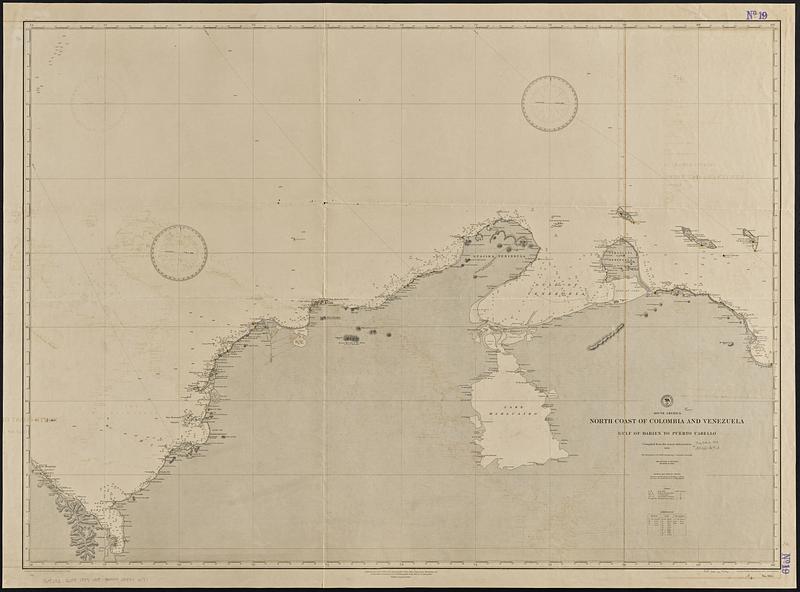
South America, north coast of Colombia and Venezuela, Gulf of Darien to Puerto Cabello : compiled from the latest information 1886
Item Information
- Title:
- South America, north coast of Colombia and Venezuela, Gulf of Darien to Puerto Cabello : compiled from the latest information 1886
- Issuing body:
- United States. Hydrographic Office
- Draftsman:
- Bolles, C. P. (Charles P.)
- Engraver:
- Ruebsam, A. C. (Adolph C.)
- Engraver:
- Sefton, W. P. (William P.)
- Name on Item:
-
drawn by C.P. Bolles ; engraved by W.P. Sefton and A.C. Ruebsam
- Date:
-
[1889]
- Format:
-
Maps/Atlases
- Genre:
-
Nautical charts
- Location:
-
Boston Public Library
Norman B. Leventhal Map & Education Center - Collection (local):
-
Norman B. Leventhal Map & Education Center Collection
- Subjects:
-
Colombia--Maps
Venezuela--Maps
Coasts--Colombia--Maps
Coasts--Venezuela--Maps
Nautical charts--Colombia
Nautical charts--Venezuela
- Places:
-
Colombia
Venezuela
- Extent:
- 1 map ; 82 x 114 cm
- Terms of Use:
-
No known copyright restrictions.
No known restrictions on use.
- Publisher:
-
Washington, D.C. :
Hydrographic Office
- Edition:
- Edition of April 1889
- Scale:
-
Scale approximately 1:985,000
- Language:
-
English
- Notes:
-
Relief shown by hachures and spot heights. Depths shown by soundings and isolines.
- Notes (date):
-
This date is inferred.
- Identifier:
-
06_01_015723
- Call #:
-
G9096.P5 svar .U55 no. 964
- Barcode:
-
39999085940177
![[Map of parts of Venezuela and Colombia]](https://bpldcassets.blob.core.windows.net/derivatives/images/commonwealth:4m90fm18q/image_thumbnail_300.jpg)